Onsite field work, research and legal action against CEP
Campaigning against Calderdale Energy Park
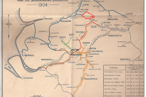
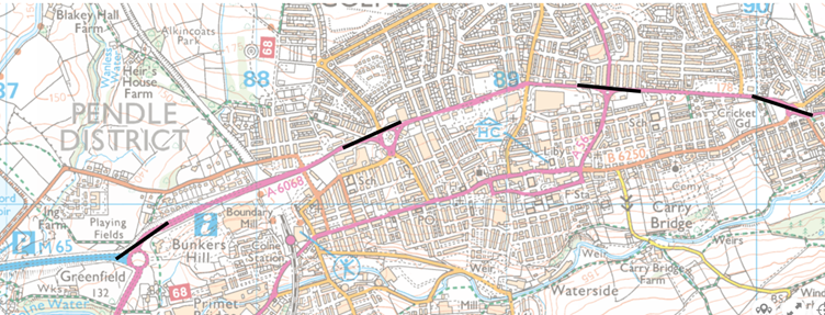
Walshaw Turbines Research Group studies the proposal to build England's largest wind farm on Walshaw Moor between Haworth, Hebden Bridge, Burnley and Colne.
Index
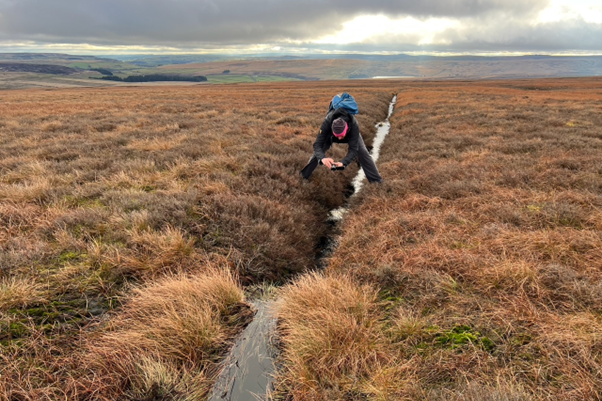
Our blogs are the record of our fieldwork and research. No WTRG author writes about a turbine site without visiting it on foot, photographing it, and researching it. Some of our blogs are here. They can all be read on our publisher Mark Avery's pages.

Windpower Monthly is the industry bible. Read the full interview given to Orlando Jenkinson which exposes the incompetence of CWF Ltd
On June 1 WTRG sent Christian Egal, Project Director a legal letter requiring the postponement of the Public Consultation into CEP. Copies have been sent to Dr Ghazi Osman (Director), The Planning Inspectorate and Robbie Moore M.P.
Lawyers working for WTRG have written a legal letter to CWF Ltd requiring a postponement to the sham "public consultation".
Option B is so poorly mapped by CWF Ltd that many people think the route is impossible. This section gives clear maps showing that Option B will be the preferred access.
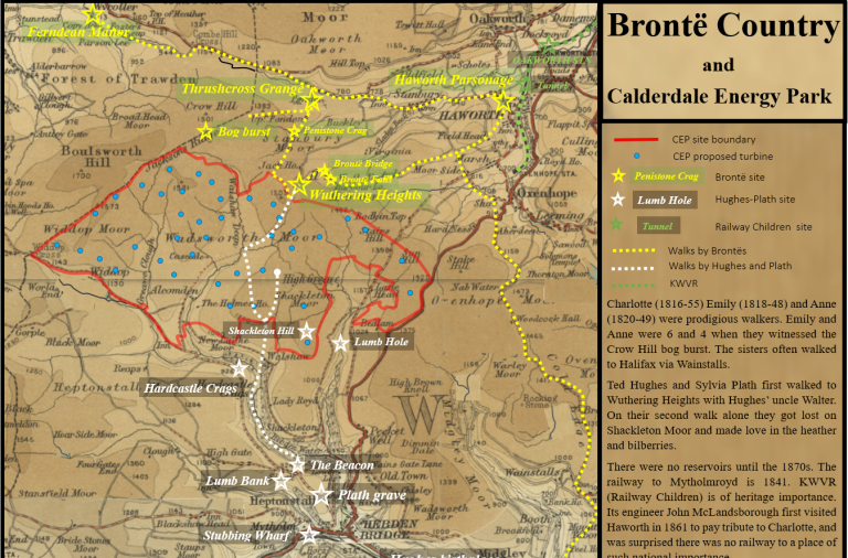
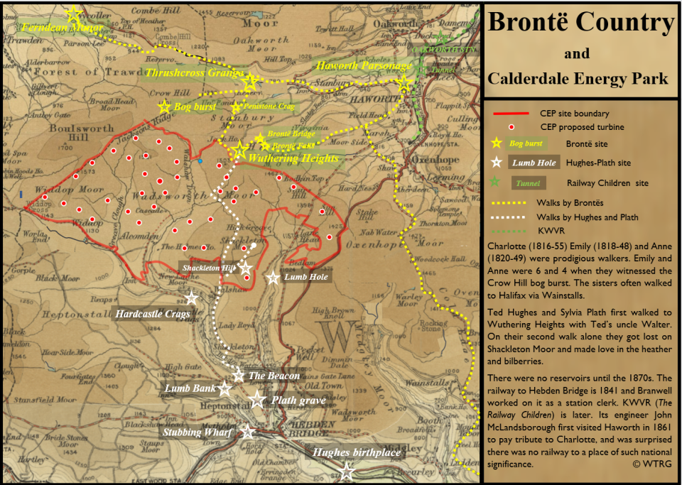
CWF Ltd have stated that CEP is "within Brontë Country". This section discusses what Brontë Country is, maps it, and asks what it means for CEP. As it develops it will publish papers by experts on various aspects of Brontë Country as it relates to CEP,
We do not collect any information on you and this website does not have an option for you to give us information. We do not collect or process your cookies. Our privacy policy is here.

Withins Height T20
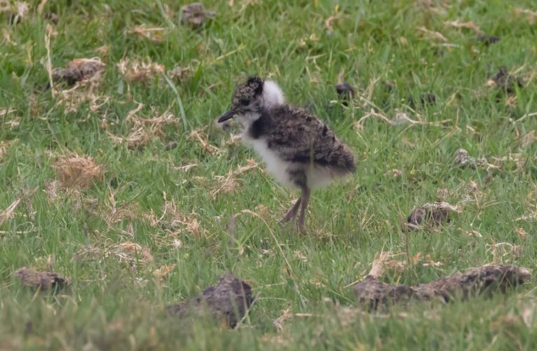
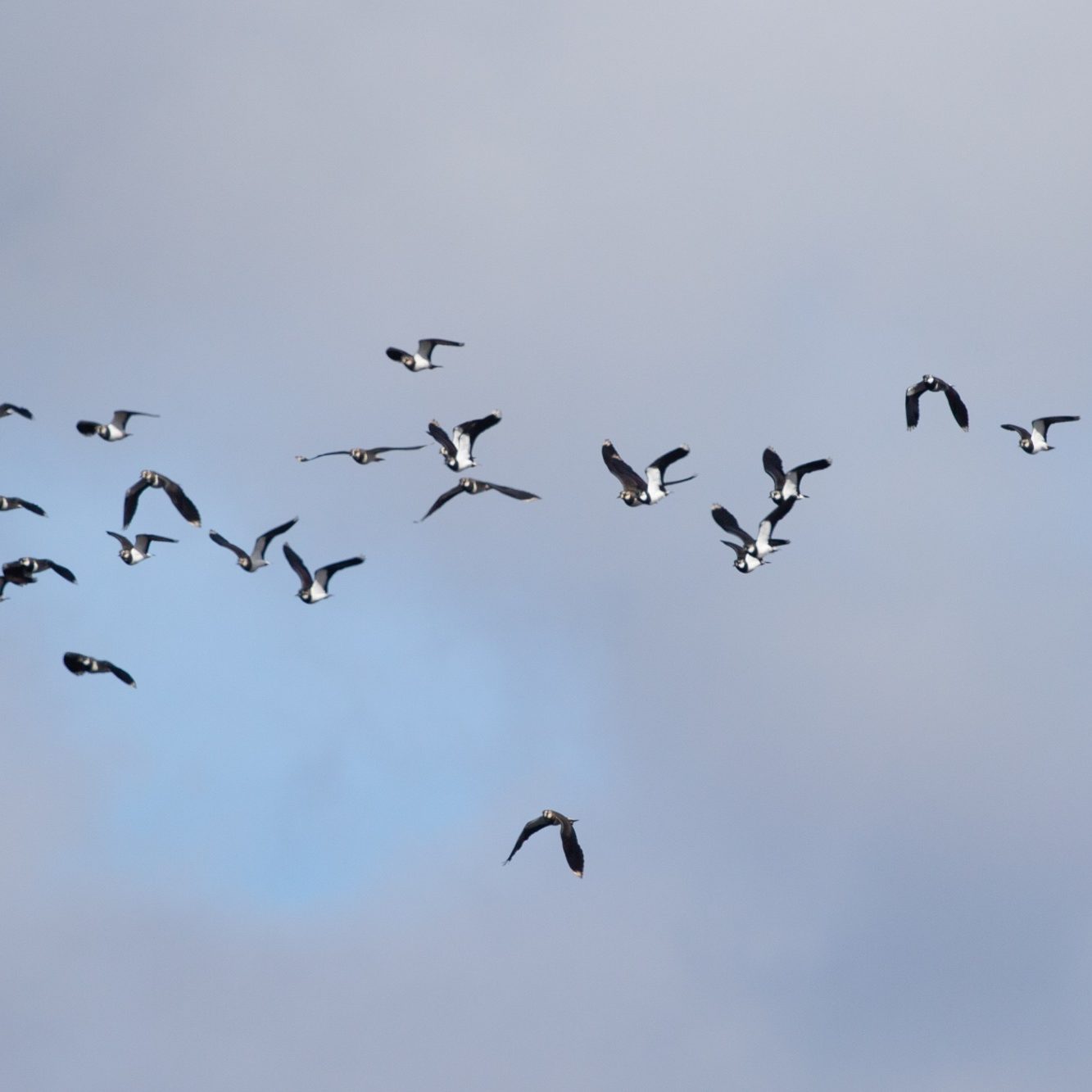
Lapwings & Curlews
Cock Hill Swamp
Grinnel Stones


Middle Moor


CEP will destroy Brontë Country
The brochure for Calderdale Energy Park states that “CEP is located within the Brontë Country, which is an area of historical and cultural importance. Given the site’s heritage value, we are committed to respecting the local historical and cultural features throughout the planning and developing process. “
The published plans exhibit the developer’s profound disrespect for the legacy and power of the Brontë heritage.
In the Guardian’s list of the greatest novels of all time, Jane Eyre by Charlotte Brontë is at no 6, and Wuthering Heights by Emily Brontë is at no 10. The highest-placed novel by a Nobel Prize winner is Lord of the Flies at no 14. The Brontë sisters are titans of British soft power: they are three of the most famous women in the history of the world.
The Lord of the Rings by JRR Tolkien is at no. 3 in the list. New Zealand had no connection with it until Peter Jackson’s films were shot there. New Zealand regard the Middle Earth landscapes as a national asset. The CEP developers intend to destroy Brontë Country, and they expect the Government to help them.
Eighty-five thousand people visit Haworth Parsonage every year, and thousands of them walk the same paths that Emily took when she walked to Wuthering Heights at Top Withins. Wuthering Heights lives vividly in the minds of Japanese women for whom the story must have a special resonance, and the signposts that guide them there read ARASHI GA OKA: Wuthering Heights. If Calderdale Energy Park is allowed to destroy Brontë Country, all these visitors will be astonished at the contempt the planners and developers have shown to these brilliant women, to an emblem of British soft power, and to a national asset.
People will ask: “Why was Brontë Country destroyed? Was there absolutely nowhere else to build this wind farm but on top of a national asset and the inspiration to three of the most famous women in the history of the world?”
Thousands come from all over the world to visit Top Withins, the inspiration for Wuthering Heights. Almost all of turbine 20 will be visible directly above Wuthering Heights. On the approach from Hawoth the Brontë skyline will be dominated by T29 on Limers Gate, T30 above Stairs and T34 on Yeoman Hill. These turbines will have a tip height of 200 metres and must be lit at night, each with two red lights. Those walking to Brontë Country from Hebden Bridge on the Pennine Way (which was a major path for the Brontës too) must pass directly under the blades of T21 on Dean Stones Edge, and all of the wildness that Emily knew will have been removed. The CEP site is rich in placenames, and all the turbine sites have a placename that the sisters would have known, for the whole site is visible from Alcomden Stones just ten minutes walk above Top Withens, and one of the most atmospheric places on the moor.
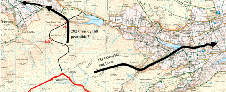
The most important Brontë site for the engineers of CEP to consider is the Crow Hill bog burst of 2 September 1824, a vast peat slide which exploded while Anne (4) and Emily (6) were in its path, sheltering from the storm in a farm porch. The boom of the exploding bog was heard in Leeds, but also in Haworth, where Patrick Brontë had to wait anxiously for the return of his children. Peat, water and huge boulders poured past the children in a torrent seven feet deep. The bog burst is very well descibed by Anne Dinsdale, Senior Curator at the Haworth Parsonage in this short video. The north apex of CEP is Option B for the site entrance. If it is chosen, then the construction workers must build a zig zag track up to Crow Hill and then cross a huge area of deep and unstable peat, by far the most complex ground on the site. This crushed rock track must then carry the 45000 lorry-loads of rock that will be used to build CEP, for the local rock, though strong in a block, is too weak, porous and susceptible to frost to make a roadstone or concrete. Local builders use limestone from North Yorkshire to build tracks, but limestone will not be permitted on the acid bog, so the developers may have to bring their aggregates from beyond Yorkshire.
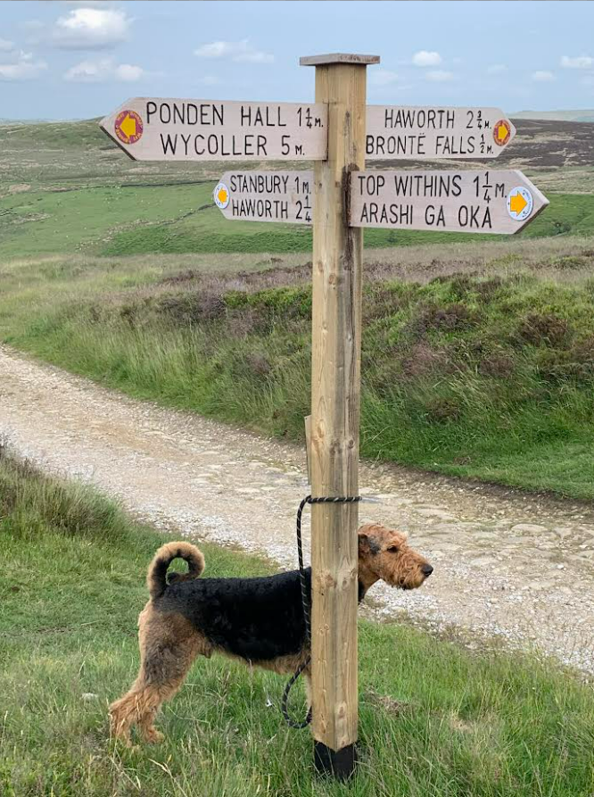
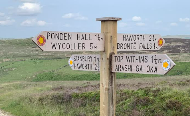
The junction of the Pennine Way and the Brontë Way. Ponden Hall is one inspiration for Thrushcross Grange in Emily’s Wuthering Heights, and the location in Anne’s novel The Teanant of Wildfell Hall.
Wycoller Hall is Ferndean Manor in Charlotte’s Jane Eyre. Uphill is Top Withins, whose location inspires Wuthering Heights itself. Emily’s novel is hugely popular in Japan and Arashi Ga Oka is Japanese for Wuthering Heights.
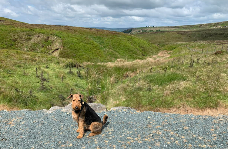
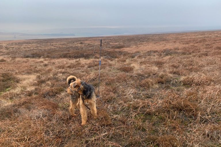
The dog is local too, an Airedale called Teddy.
Letter to the TLS
OPEN LETTER TO THE TLS, FEBRUARY 2024
Dear Martin Ivens,
Thirty years ago, Ted Hughes, Jeanette Winterson and 62 other signatories stood against an “assault on our literary and artistic heritage”: a proposal to build 44 wind turbines on the moors above Haworth, the West Yorkshire home of the Brontës.
We, the undersigned, are standing again – this time, against an impending planning application for England’s largest onshore wind farm on this area of international literary significance and ecological importance. At 200 metres tall, the 65 proposed turbines would be two-thirds the height of the Eiffel Tower. They would be visible for 40 kilometres, would be served by miles of access roads across fragile peat.
These are not just the wuthering heights written into immortality by the Brontës, Ted Hughes and Sylvia Plath, or the wily, windy moors sung about by Kate Bush - they are a unique, highly protected, priority habitat. The turbines would occupy 11 Site of Special Scientific Interest land units which also have European Natura 2000 status (now transferred into UK law post-Brexit.) The area is also home to protected, endangered birds like breeding merlin, golden plover, and other breeding bird assemblages, including curlews. The peat moors include significant areas of blanket bog – as the biggest natural storers of carbon in the UK, blanket bogs are known as the UK’s Amazon rainforest. Their unique hydrology offers a protective barrier during extreme rainfall which reduces peak flow during repeated floods in the Calder Valley and other areas. And they are loved, as a vital green resource for mental and physical health by inhabitants and visitors from Burnley, Bradford, Leeds, and the industrial North, and by literary pilgrims from across the world.
Along with the RSPB, the Brontë Society, Lancashire and Yorkshire Wildlife Trust and the Campaign for the Protection of Rural England and multiple other organisations, we oppose this proposal on the grounds of the profound ecological and cultural harm it would cause. In the movement towards net zero carbon, we need long-term solutions which restore habitat and biodiversity; which are alert to the value of culture and community, and which enhance natural carbon storage in oceans, forests, peat, and other soils.
Yours sincerely,
Alan Ayckbourn, Frieda Hughes, Robert Macfarlane, Sally Wainwright, Jeanette Winterson
and 351 signatories:
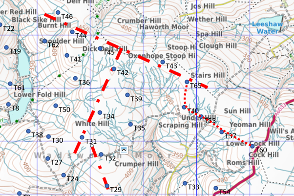
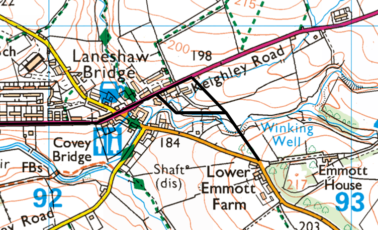
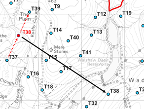
Option B: proper maps
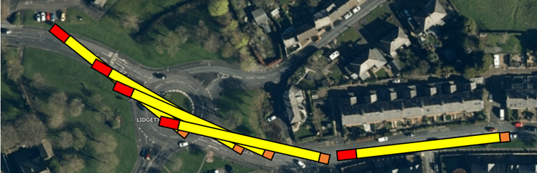
These maps of Option B will clarify the position for land-owners and members of the public. In the opinion of WTRG, Option B will allow the delivery of 85-metre blades lying flat. It requires third-party land and some widenings that will also require temporary use of third party land. Tracks would be built across the Colne roundabouts and street furniture removed. These are all normal in turbine deliveries.
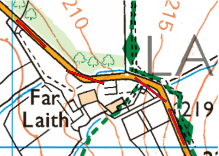
The maps only show the most difficult section of the Two Laws Road from Laneshaw Bridge to Watersheddles Reservoir. To straighten this section will require third-party land around Far Laith. A full analysis will appear in the Blog on "Jackson's Ridge Compound" by Nick MacKinnon which will be published on 4 July 2025 by Mark Avery.
The first map shows the bypasses of Laneshaw Bridge. Only one of these is needed, and the southerly one does not allow an 85-metre blade to turn.
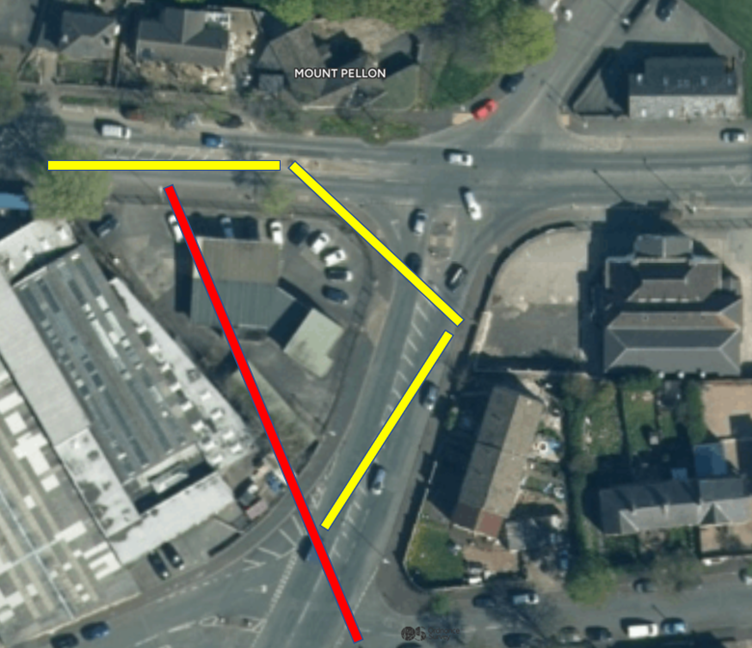
The second map shows the Colne bypass. Temporary tracks will be built across the roundabouts and all signage and public art removed. This is routine in turbine delivery. The link shows Collets negotiating a roundabout with an 80-metre blade.
The last roundabout needs a closer look. The diagram shows an 85-metre blade with a 10-metre tail in red that can oversail low walls with third-party permission. Signage would be removed and a track built across the roundabout.
The Two Laws Road is usually wide enough and straight enough. The bends round Far Laith will need third-party land. This will probably be a widening before the bends and an intrusion into Far Laith yard. WTRG does not expect that the fine trees will be cut down, which is the other option here. Other bends on the road will require similar temporary widening.
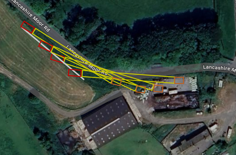
This diagram shows one way of negotiating the Far Laith chicane. WTRG does not approve of this use of third-party land and the diagram is indicative.
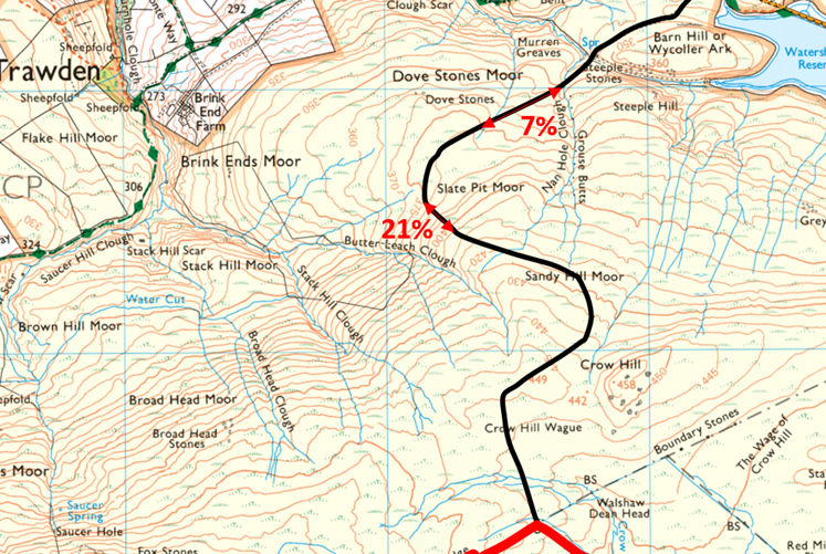
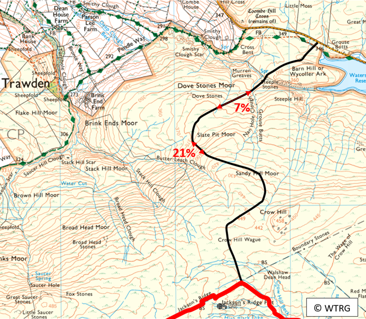
The track turns onto Richard Bannister's land at the Peat House. This moorland track has a 21% section which is much too steep for a standard delivery. Directly up the line of the grouse butts would be initially 15%, also too steep for a standard delivery.
Option A through Halifax and Wainstalls past Ovenden Moor Wind Farm uses the route proved for the delivery of the 40-metre Ovenden Moor blades. The yellow 40-metre blades making the turn. If the 85-metre blades are raise to 60 degrees, they become 42.5 metres long in plan view and the yellow path can be followed.
In the forthcoming blog WTRG will explain why Option B is most likely to be preferred.
The case to postpone the CEP Public Consultation
Almost everyone who has been to the CEP events during the six week "Public Consultation" from 29 April - 10 June has been amazed by the poor organisation of the process and by the weakness of the replies they have had to their questions. Public consultations are not meant to be like this, and there are four long established rules for how they must be conducted called the Gunning Principles. WTRG have used their knowledge of the terrain and the project to prepare the following case, which is the basis for the WTRG legal team letter. This document is a dry legal summary of the research published in the blogs. In a public consultation, people must have enough information to make "intelligent consideration" to the proposal. We show here that CWF Ltd themselves did not have enough information to give their own project "intelligent consideration" and that the incompetence that was the hallmark of the original CWF proposal has spread like dry rot to CEP.
This document accompanied the letter sent on June 1 2025
1 Introduction to CEP
[1] Calderdale Wind Farm Limited (CWF Ltd) have advanced a proposal to build England’s largest wind farm on Walshaw Moor between Haworth, Hebden Bridge and Colne. This proposal is Calderdale Energy Park (CEP) and it replaces an earlier proposal called Calderdale Wind Farm (CWF).
[1.1] CWF was a proposed 302 MW, 65 turbine array. CWF was specified in a Scoping Report (September 2023) and by information published on the CWF website. The Scoping Report was written by Natural Power, who are still engaged by CWF Ltd in the CEP proposal. The area of CWF was 2352 ha, about 9 square miles. There was the possibility of a BESS, a 150 MW battery storage system, and of solar panels between the turbines.
[1.2] CWF was going to be submitted for planning permission to Calderdale Council “in the summer of 2024”. In October 2024 CWF Ltd decided not to put CWF forward.
[1.3] On 29 April 2025, CWF Ltd launched CEP a 300 MW, 41 turbine array. It has the same boundary as CWF. To achieve the stated power, the turbines will be 7.3 MW models with a blade length of 85 metres and a rotor diameter of 170 metres. Although this information is essential to give the proposal intelligent consideration, it is not found in the brochure or website and is the result of private research, but it has been confirmed by CWF Ltd in a phone call from Oliver Dorgan.
[1.4] Also on 29 April 2025, CWF Ltd launched a six-week “non-statutory consultation” with the local community and stakeholders on their proposals to date.
[1.5] As far as the public are concerned, the details of CEO are specified by a printed document called the Consultation Brochure which reproduces the maps and information on the CEP website.
[1.51] The maps on the website are superior in that they include a panel with serial numbers of the maps and underlying layout, the initials of the consultants who drew up and checked the maps, and the dates the maps were finalised.
2 Walshaw Turbines Research Group
[2] Walshaw Turbines Research Group (WTRG) campaigned against CWF and continue to campaign against CEP. The group has grown as people contribute. They adopted the name WTRG to constitute a legal entity. They have a website (walshawturbines.com) which is used as a channel to publicise their research blogs and other materials.
[2.1] The method of WTRG is to study the turbine sites one by one and write a long blog (2000-8000 words) with photographs (10-20) and bespoke maps, focussed on a single turbine site. The group use their skills in cartography, engineering, applied mathematics, ornithology, peat science, economics, nature photography, poetry, and history to develop and promote a multi-disciplinary understanding of Walshaw Moor, CWF and CEP.
[2.11] Working on a turbine-by-turbine basis ensures that the multi-disciplinary approach is always concretely applied to the proposal for a wind farm on Walshaw Moor.
[2.2] Membership of WTRG is open, but all members do fieldwork and contribute to research. The blogs are edited by Nick MacKinnon and reviewed by Dr Mark Avery who publishes them on his widely read blog Mark Avery: Standing Up for Nature. Dr Avery is a prominent conservationist and the former Conservation Director of the RSPB.
[2.21] The WTRG blogs are widely read by an average of 2000 people per issue, who include many prominent at the intersection of public policy and the environment. The blogs have also been closely read by consultants working for CWF Ltd.
3 Walshaw Moor: habitats and cultural heritage
[3] Walshaw Moor is at the pinnacle of the hierarchy of protected habitats in England (conservation is a devolved matter) and is also of unique cultural and heritage importance because of its connection with the Brontë sisters; the Poet Laureate Ted Hughes; his wife Sylvia Plath who is buried 4 km south of CEP; and the photographers Bill Brandt and Fay Godwin.
[3.1] Walshaw Moor is part of the South Pennines Moors SPA and SAC and is a Natura 2000 site.
[3.11] It is a Special Area of Conservation (SAC) for its extensive deep peat, blanket bog, and acid grassland habitats. It is a Special Protection Area (SPA) for its breeding populations of ‘red-listed’ birds (ie birds of conservation concern) such as as merlin, golden plover, curlew, skylark, and lapwings. The SPA and SAC designations are international since they are Natura 2000 sites and the laws that underpin them were transposed from EU law after Brexit.
[3.12] Walshaw Moor has a Natural England restoration plan that runs from 2017 to 2042.
[3.2] In 2022 the UK led the adoption of the Kunming-Montreal Protocol at COP 15. This commits the 196 signatory countries to effective area-based conservation measures on 30% of their land and seas by 2030. England is one of the most nature-depleted countries in Europe and achieving the 30 by 30 target will be very difficult.
[3.21] Defra have published a map indicating how progress will be made. At its heart are the internationally designated SPAs and SACs, representing about 7% of the 30% target. Destabilising the protection of Walshaw Moor will undermine England’s approach to Kunming-Montreal, because it will mean even the most highly protected areas can be developed and may not count towards the 30%.
[3.3] The developers of CEP have stated that CEP is “in Brontë Country”, the landscape that inspired Charlotte and Emily and Anne Brontë to write their celebrated novels and poetry. A measure of the significance of the Brontë sisters is that the Guardian’s list of the hundred greatest novels of all time has Jane Eyre by Charlotte Brontë at no. 6, and Wuthering Heights by Emily Brontë at no. 10. The highest-placed novel by a Nobel Prize winner is William Golding’s Lord of the Flies at no. 14.
[3.31] Because the landscape is a hero of these outstanding novels, people come from all the world to visit the Brontë Parsonage museum (85000 visitors per year) and thousands walk onto the moors, especially to Top Withins, whose location is widely believed to be the inspiration for the location of Wuthering Heights in the novel of that name.
[3.311] Top Withins draws people from all over the world, and the signpost below the ruin is in romanised Japanese: Arashi ga oka = Wuthering Heights. The theme of sexual desire transcending social boundaries is said to resonate with the Japanese, and the novel forms part of their school curriculum.
[3.32] It is important to realise that it is the location of Wuthering Heights at the boundary of civilisation and wild moor that generates the novel’s charge. Visitors experience this by walking a few minutes uphill behind Top Withins to the Calderdale and CEP boundary, where they suddenly apprehend the vastness of Walshaw Moor.
[3.33] Walshaw Moor and its surroundings was also a very significant place for Poet Laureate Ted Hughes (born in Mytholmroyd 5 km south of CEP) and for his wife Sylvia Plath, who is buried under the name Sylvia Plath Hughes in Heptonstall, 3.5 km south across the valley from turbine T36 of CEP.
[3. 34] The view of 351 experts working at the intersection of the environment and the creative arts to the heritage aspects of the CWF proposal in Brontë Country was made clear in their letter to the Times Literary Supplement (16 February 2024). Among the signatories were Frieda Hughes, Robert Macfarlane, Sally Wainwright, and Jeanette Winterson.
[3.4] The Pennine Way runs through Walshaw Moor and is an important aspect of cultural heritage. It is the UK’s oldest National Trail, and this year celebrates its Diamond Jubilee. The idea for it came to the journalist Tom Stephenson when he talked to two young American women about the John Muir and Appalachian trails in the USA which saved areas of wilderness for all time from unplanned and irresponsible building, and he advanced the idea in an article in the Daily Herald in 1935. In 1965, aged 72, Stephenson walked the Pennine Way and wrote the first guidebook.
4 The catchment and flooding
[4] Walshaw Moor is a catchment area that serves Widdop reservoir and the three Walshaw Dean reservoirs that divide the site of CEP. All the runoff from CEP passes through Hebden Bridge, which has suffered numerous severe floods, the most recent being in 2012, 2015 (Storm Eva) and 2020 (Storm Ciara). There are currently proposals to raise flood defences in Hebden Bridge. These proposals, which are budgeted at £90 million, do not allow for any increase in flood risk from CEP. It is for CWF Ltd to show that CEP will not increase the flood peak in Hebden Bridge and downstream.
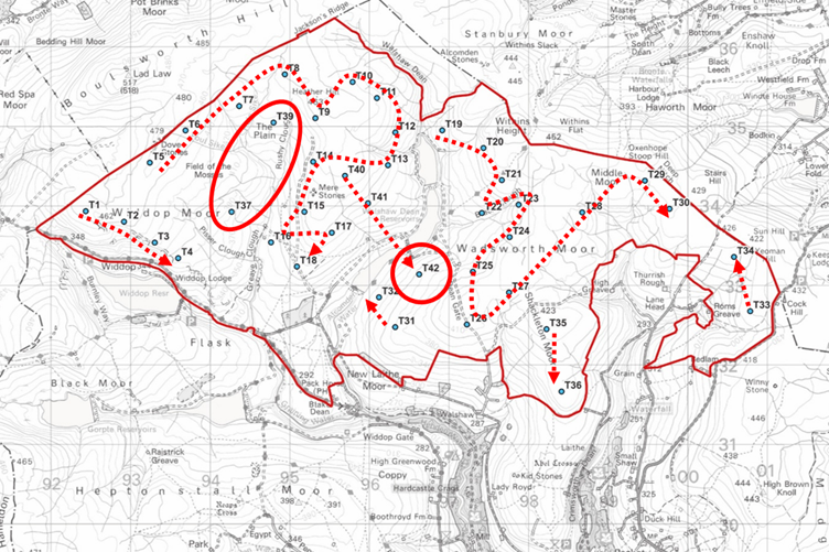
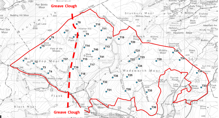
[4.1] In the discussion of the CEP proposal, the area “west of Greave Clough” will be of special importance and the area is shown in fig 4.1 where the “Greave Clough catchment” is also defined.
[Fig 4.1 Greave Clough is the red dashed line. The “Greave Clough catchment” in CEP is triangle formed by the T1 -T4 watershed, the NW boundary and the watershed joining T8, T14, T15 and T18. Source: CEP layout map with a red highlight by WTRG]
The case to postpone the CEP public consultation
5 The CEP proposal is too careless to be fit for public consultation
[5] It is the purpose of this paper to show that CEP proposal is too careless to allow the public intelligent consideration of it.
[5.1] The paper will also show that crucial documents that might have allowed CWF Ltd to undertake a careful design process are wrong and that these incorrect documents also prevent the public from giving intelligent consideration to the proposals.
[5.11] The paper will show that the results of a careless design process visible in the layout are so stark that it is almost impossible to give intelligent consideration to the deeper problems in the proposal, which are to do with the habitats, the profusion of breeding red-listed birds, the release as CO2 of oxidised peat, the flood risk, and the degradation of what the developers call “Brontë Country”.
[5.12] The paper will show that some of the documents are so faulty that CWF Ltd themselves were unable to give their own proposal “intelligent consideration” which is a test of a correct public consultation under the Gunning Principles.
[5.13] Furthermore the paper will show that the carelessness in the documents is systemic, so that the errors generate further errors.
[5.2] In order to give intelligent consideration to any proposal in a public consultation it has to be free of elementary mistakes so that it can be taken seriously with respect to more complex matters. If the mistakes are flagrant the public may think they have been deliberately inserted to distract attention, the ‘dead cat’ technique.
[5.21] The documents supporting any planning proposal should be complete and accurate so that the public can see how the proposal relates to the documents and can use the documents to give intelligent consideration to the proposal.
[5.22] CWF Ltd themselves should also have access to accurate and complete documents that will allow them to make a careful proposal.
[5.3] In sections 6-14 we shall detail aspects of the proposal that are evidence of a careless design process and describe errors in the maps which render them inadequate for a careful design process and inadequate for a public consultation.
Analysis of systemic carelessness and incompetence in the CEP proposal
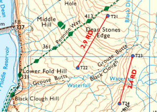
6 Turbine 21 is too close to the Pennine Way
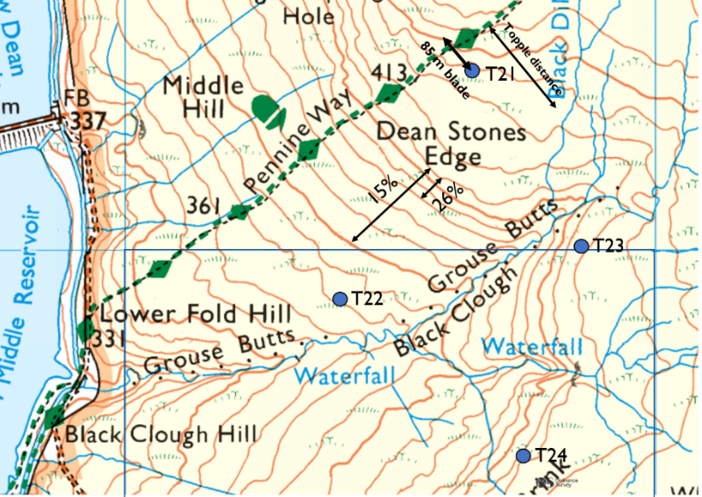
[6] T21 is less than 60 metres from the Pennine Way, the most famous national trail in the UK (fig. 6).
[Fig 6. T21 is within 60 metres of the Pennine Way and the blades are likely to be 85 metres long. [WTRG map published 9 May 2025]
The case to postpone the CEP public consultation
[6.1] Since the CEP turbines will be 7 MW models, the blades will be 85 metres long, Walkers will have to pass under the rotating blades. To protect the public areas, General Electric give a minimum set back of “topple distance plus 10%”, here 220 metres.
[6.2] T21 is so close to the Pennine Way that the cartographer of the access map (fig. 6.2) had to deviate from the OS line when tracing it in green and yellow to avoid a clash with the turbine. As well as being unsafe, T21 is not an appropriate way to mark the Diamond Jubilee of the Pennine Way.
[6.3] We conclude that T21 is evidence of a careless design process with regard to public safety, public access, and the cultural heritage of the Pennine Way.
[Fig 6.2. T21 and the Pennine Way as they appear on the CEP Access map.]

The case to postpone the CEP public consultation
7 T22 in Black Clough is inaccessible
[7] T22 in Black Clough must be accessed from T21 by a crushed rock track down a gradient of 26% (fig 7.2) far more than what is safe for construction workers or normal. The HSE give a figure of 1:12 (9%) for HGVs on industrial sites. Scout Moor wind farm in the Pennines has one downhill delivery spur of 12%. Abnormal Indivisible Loads will include the 300-tonne pylon sections, the 300-tonne nacelle, and a 200-tonne mobile crane. The other loads will include hundreds of HGVs bringing crushed stone, rebar steel and concrete.
[7.1] A site visit to T22 would have shown CWF Ltd that there is considerable unmapped waterflow between the Pennine Way and the track line to T22; the track and drains to T22 would accelerate this drainage in a storm.
[7.11] A site visit would also have found that the peat is a lot deeper between T21 and T22 than the Peat Depth map shows. WTRG found some peat was 2 metres deep on the track line.
[7.12] Where the track from T21 to T22 is on less steep terrain the ground is much wetter than the CEP hydrology map shows, and the peat is much deeper than the Peat Map shows. Where the gradient steepens to 26% the track line is on less deep peat, but the gradient is far in excess of what is safe or feasible.
[7.2] We conclude that T22 is evidence of a careless design process.
[Fig 7. Access to T22 is down a 26% edge. [WTRG map published 9 May 2025]

The case to postpone the CEP public consultation
8 The cluster T21, T22, T23 and T24 are much too close together
[8] A wake of slow turbulent air forms behind a wind turbine. Correct downwind spacing of turbines allows the wake to disperse so the downwind turbine can work efficiently.
[8.1] Standard down wind spacing is 7 Rotor Diameters (RD) in the direction of the prevailing wind. There is a compromise between inefficiency due to “wake losses” and the price of land for spacing. RenewablesUK Cymru used 5 RD when calculating the maximum availability of the wind resource in Wales, for example. The standard scientific paper on the matter gives 15 RD as an optimum spacing.
[8.11] The authorities’ view of considered downwind spacing is between 5 RD and 15 RD.
[8.2] T21 and T22 are 2.9 RD apart in the direction of the prevailing SW wind. T23 and T4 are only 2.2 RD apart (fig. 8.2).
2] The spacing of T21, T22, T23 and T24 is evidence of a careless design process.
[Fig 8.2. The cluster T21, T22, T23 and T24 are much too close together. WTRG map published 9 May 2025]
The case to postpone the CEP public consultation
9 The hydrology map has a fundamental error
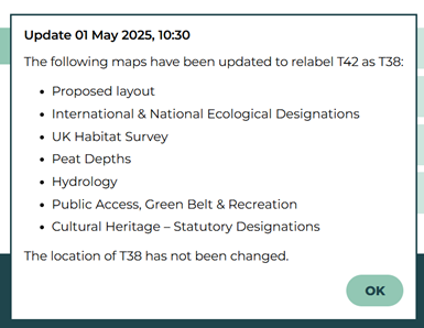
[9] The hydrology map had a careless error at launch and still has a fundamental error.
[9.1] The CEP hydrology map was wrong in three ways on the launch day, 29 April 2025. The two simple errors was corrected at the instigation of WTRG, who were thanked in a letter from CEP Project Director Christian Egal.
[9.11] The simple errors were that there was no T38 but there was a T42. The error was on seven maps (layout, hydrology, peat depths, access, ecological designations, cultural heritage, UK habitats) and is acknowledged on the website with a pop-up notice (fig. 9.11).
[9.12] The causes of the T38-T42 errors involved systemic carelessness and are described in section 11.
[Fig 9.11. The pop-up notifying the public that seven maps have been corrected. CEP website from 10:30 1 May 2025]
The case to postpone the CEP public consultation
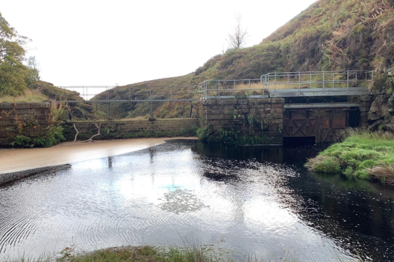
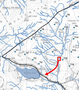
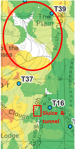
[9.2] The fundamental error in the hydrology map is that it fails to show the correct water flow out of the Greave Clough catchment (fig. 9.2 left). The map shows water flowing into Graining Water directly, where in fact the water (in normal conditions) is intercepted by a sluice and sent down a tunnel to Widdop Reservoir (fig. 9.2 right).
[Fig 9.2. The CEP hydrology map (left) does not show the correct flow from the Greave Clough catchment. A sluice and tunnel divert the flow into Widdop Reservoir. [CEP hydrology map and WTRG highlight]
The case to postpone the CEP public consultation
[9.21] Thirteen turbines (T2, T3, T4, T5, T6, T7, T8, T9, T14, T15, T16, T37, T39) of CEP affect the hydrology in the Greave Clough catchment that is focussed at the sluice. The tracks and associated drains will be even more important in altering runoff rates. Assessment of flood risk here is crucial to the safety of people in the Calder valley, particularly in Hebden Bridge which has been subject to multiple catastrophic floods since 2000.
[9.22] Since all the runoff in this catchment is focussed on the Greave Clough sluice and tunnel (fig. 9.22) the point must be shown on the hydrology map. Effective site visits by the hydrology team would have discovered this crucial matter. No effective site visits to the Greave Clough catchment by the CEP hydrology team can have taken place.
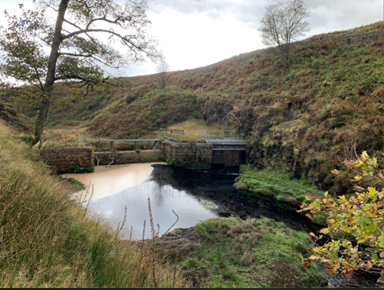
[9.23] The focused nature of the Greave Clough catchment must be constantly in mind during a careful design process and therefore must appear on the hydrology map. The absence of the sluice and tunnel on the hydrology map shows incompetence in the design process.
[9.3] One of the most evident ways in which CEP might increase catastrophic flood risk is that the hard infrastructure and drainage for CEP in the Greave Clough catchment accelerates the runoff that arrives at the sluice. The tunnel is overwhelmed and the sluice overflows down a spillway. This water reaches Hebden Bridge directly rather than via Widdop reservoir.
[9.4] Since the hydrology map was so deficient, we conclude that the design process with respect to the hydrology of catastrophic flooding was so careless as to be incompetent.
[Fig 9.22. In normal conditions all the Greave Clough catchment runoff passes through this sluice and is diverted by a tunnel (on the right of the photograph to Widdop Reservoir. In extreme conditions the tunnel is overwhelmed, and the runoff goes directly to Hebden Bridge over the sluice dam. [Photo: Nigel Griffiths WTRG]
The case to postpone the CEP public consultation
10 The peat depth map is incomplete
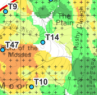
[10] The peat depth map has a large blank section in the Greave Clough catchment (fig. 10).
[10.1] The peat depth map was published on 29 April 2025 and corrected at the instigation of WTRG at 10.30 1 May 2025 (the T38-T42 error) and corrected again at the instigation of WTRG on 2 May 2025 (incorrect key). In the printed Consultation Brochure the correction was made with a printed sticker.
[10.2] The peat depth map was the most important document in the CWF Ltd planning process for the CEP turbine layout.
[10.21] The original 65-turbine CWF had many of its turbines on very deep peat (up to 3 metres deep) or required tracks to pass over very deep peat to reach them.
[10.22] The primary objective in planning the CEP layout was to put the turbine sites onto peat of less than one metre depth. In the CEP peat depth map only 6/41(15%) turbines are on peat that is shown as more than one metre deep. In the CWF peat depth map 26/65 (40%) were of that kind. None of the CEP turbines are on two-metre-deep peat but 15 of the CWF turbines were on peat of this depth or greater.
[10.23] Given that the peat depth map was so important, it is remarkable that it is so incomplete. The fact that the blank area is above the Greave Clough sluice and tunnel makes the issue systemic.
[10.24] Since the hydrology team did not make an effective visit to the Greave Clough catchment, it may even be that the full seriousness of the blank area to hydrology and flooding was unknown by the design team who made the CEP layout. Certainly, two of the consultants involved in the layout design had never seen a photograph of the Greave Clough sluice when they were shown one.
[Figure 10. The blank area of the peat depth map west of Greave Clough relative to the Greave Clough sluice. Red highlights added by WTRG.]
The case to postpone the CEP public consultation
[10.3] The blank area in the peat depth map is caused by CWF Ltd’s failure to complete the peat probing in 2022 and by their repeated subsequent failures to remedy the problem. The same incomplete data was used to make the Scoping Report map of 2023 and the CEP map. The probing failure is revealed in the 2023 map (fig. 10.3) because it shows the positions of each probing with a cross. The Kriging algorithm used to colour the map gives up when the data is completely insufficient and the blank area is the result.
[Fig 10.3. The 2023 Scoping Report version of the peat depth map shows the probing positions. CWF Scoping Report 2023]
The case to postpone the CEP public consultation
[10.31] The position is worse because the Kriging algorithm has coloured speculatively in areas where there is little nearby probing. In all, CWF Ltd had inadequate information about peat depths in 14% of the Greave Clough catchment (fig 10.31)
[10.32] The public are also not in possession of adequate information, and this is another reason that they cannot give the proposal intelligent consideration.
[10.32] Failing to complete the peat survey between 2022 and the CEP launch date on 29 April 2025 was extremely careless, since fieldwork undertaken by WTRG in the area shows that it could have been completed by a competent team in one day.
[10.4] It is impossible for the public to give intelligent consideration to peat destruction by turbine placement and track building in the area west of Greave Clough because of the failure to complete the survey.
[10.41] It is impossible to calculate the stone requirements of CEP because neither the public nor CWF Ltd can model the track network when the peat depths are so uncertain. Where the tracks go determines flood hydrology, and neither CWF Ltd nor the public can say anything about flood risk. Since CWF Ltd had also not marked the Greave Clough sluice and tunnel, the layout west of Greave Clough is wholly speculative.
[10.5] In the area west of Greave Clough the carelessness of CWF Ltd is systemic because the hydrology map is wrong and the peat survey is incomplete. The turbines T1, T2, T3, T4, T5, T6, T7, T8 and the oddly punctured sequence T37, (T38), T39 have been positioned without reference to an adequate peat map nor an adequate hydrology map.
[10.6] The interaction of the unreliable peat depths and the wrong hydrology means that the design process of CEP west of Greave Clough is incompetent.
[Fig 10.31. The peat depths are uncertain inside the red boundary and the area constitutes 14% of the Greave Clough catchment. [WTRG on 2023 peat survey]
The case to postpone the CEP public consultation
11 The phantom turbine
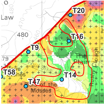
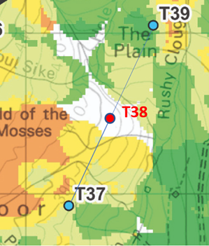
[11] The anomalous position of T38 now becomes further evidence of how compromised the layout design west of Greave Clough was.
11.1 The turbine numbering is sequential. On the ‘launch day’ maps there was no T38, but there was instead a T42 on the location where T38 is now to be found (fig. 11.1). The cause of the error can be reconstructed from the dates and codings marked on the full versions of the maps. The layout was finalised for the purpose of the launch of CEP on 21 February 2025. (Layout designation 210225-41t).
[Fig 11.1. On the layout published on the launch day 29 April 2025 there was no T38 but there was a T42. The figure is a WTRG screenshot of the deleted layout map (preparation date 14 March 2025) with WTRG red highlights]
The case to postpone the CEP public consultation
11.11 Before the layout was finalised, T38 (then between T37 and T39 in a sequence) was deleted, and the only plausible explanation is that it was on the blank area in the peat survey (fig, 11.11), when peat depth was primary in the layout design. There were now 41 turbines but one of them was still called T42.
11.12 The layout was given as a spreadsheet of turbines and six-figure grid references to the cartographer JWO at Natural Power who made seven faithful maps with no T38 and a T42 on 14 March 2025. The maps were checked by LF. These maps were loaded to the CEP website.
[11.121] The helpful receptionist Emma at Natural Power did not recognise JWO and LF when WTRG rang the Castle Douglas office and could not find them in the Staff Directory. She found James Lightbody who spoke to WTRG. He had “worked with CWF Ltd some time ago” but did not know who JWO and LF were.
[Fig 11.11 The sequential position of T38 would have been between T37 and T39 in the blank area on the peat depth map. WTRG highlight on 2025 CEP peat depth map]
The case to postpone the CEP public consultation
[11.13] The T42 mistake was noticed, and a new set of maps were made by JWO on 18 April 2025 just eleven days before launch. The correct maps were not loaded to the website, and on 29 April 2025 the website maps had no T38 but a T42. WTRG pointed out the error at 09:04 1 May 2025 and the correct maps were substituted at 10:30 (fig 11.13) with T38 out of sequence on the previous site of the phantom T42.
[11.2] For some reason, somebody added the statement on the pop-up correction that “The location of T38 has not been changed.”
[11.21] Given the sequential numbering, this is implausible, and at the Oxenhope public consultation a consultant who had been present during the layout design admitted that T38 had been moved from between T37 and T39 to the position of the phantom T42 but said, “The reason for the move was not that it had been on the blank area”. Since CEP had printed an implausible statement that the consultant had just admitted was false, there is no reason to believe the implausible statement of the consultant either, especially as it was made ad lib.
[11.3] All this happened because of the cardinal failure of CWF Ltd to complete the peat survey before attempting a layout design, when the fieldwork would have only taken one day.
[11.31] CEP consultants have given two reasons why the fieldwork was not done between 2022 and 21 February 2025 when the CEP brochure was finalised. “The ground might be too dangerous.” “Weather”. Neither stand up to examination, and they reveal a lack of understanding of the terrain. A WTRG member has probed the peat in the blank area, and far from finding it dangerous was able to do complete the central transect in thirty minutes while also managing a research assistant.
[11.4] T38 might have been moved because of hydrology except that CWF Ltd were ignorant of hydrology in the Greave Clough catchment.
[11.41] Since T38 was moved, the public must wonder why the pop-up correction says it was not moved.
[11.42] The contradictory statements about T38 suggest that CWF Ltd are uneasy about the matter.
[11.43] As no plausible explanation has been given by CWF Ltd, the simplest explanation is that CEP’s design process was influenced by the blank area on the peat survey, and this caused the subsequent errors in a systemic manner.
[11.5] Given the situation described, the public can have no confidence in the design process.
[11.6] This web of errors beginning in 2022, is evidence of systemic incompetence in the CEP layout design process.
[Fig 11.13. T 38 has been moved from its original position in sequence to the position of T42. WTRG highlights on the CEP layout post 10:30 1 May 2025]
The case to postpone the CEP public consultation
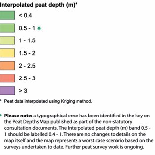
[12.1] A second example of systemic carelessness is found in the error in the Peat Depth Map key, corrected by sticker in the brochure and by an asterisked correction on the website map. (Fig. 12.1)
[Fig 12.1 The second correction to the Peat Depth Map as it appears on the CEP website. The same information is on a sticker in the Consultation Brochure.]
The case to postpone the CEP public consultation
[12.11] This “key error” is of long gestation, In Scotland the definition of “deep peat” is 0.5 m or more, In England it is presently 0.4 m, with a move to 0.3 m under discussion. Perhaps because Natural Power are Scottish-based, the 2023 Peat Depth Map used 0.5 m as the depth of the shallowest peat, an error that was commented on by many.
[12.12] In the 2025 Peat Depth map the same 2022 data is used to recompute a 0.4 m depth contour, which the Kriging algorithm has done. A human failed to update the key, so there was now a gap between 0.4 m and 0.5 m.
[12.13] WTRG pointed this out to CWF Ltd on 1 May 2025, and the clumsy corrections were made to the website map and the brochure.
[12.2] Although the correction calls the error “typographic” we see that it is evidence of systemic carelessness and derives from the original failure to check the definition of deep peat in England and then to check the maps properly.
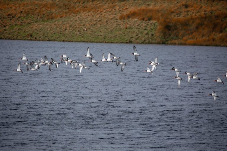
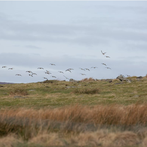
[12.21] The correction claims that “Further peat survey is ongoing” when it cannot be because breeding red-listed birds may not be disturbed under the SPA designation. The birds are present in huge numbers, which is why Walshaw Moor is designated an SPA. (Fig 12.21) This error is systemic. It was made while explaining the error in the key.
[Figure 12.21. A huge flock of curlews over Walshaw Moor on 29 March 2025. Photo: Kate Haslegrave.]
The case to postpone the CEP public consultation
[12.22] “Ongoing peat work” would therefore be damaging to the conservation interest for which this site is designated. No peat work should be done until the chicks have fledged and left the moor for wintering grounds. Fieldwork in this area in the middle of the breeding season is potentially a plan or project which would require permission from Natural England (NE) and WTRG have informed NE of the possibility of such work going ahead in the Walshaw Moor SPA.
[12.3] The correction also states that the Peat Depth Map is a “worst case (sic) scenario” and not a representation of peat depths inside the boundary of CEP after all. The public, trying to give intelligent consideration to CEP, do not know the direction of the axis “bad-case scenario, worse-case scenario, worst-case scenario”: is it worse for CWF Ltd or worse for the curlews?
[12.31] In 14% of the Greave Clough catchment there is no scenario at all because neither the public nor CWF Ltd can give intelligent consideration to peat loss and degradation when the data is absent or unreliable.
[12.4] It is not possible to model the tracks west of Greave Clough because of the unreliability of the Peat Map.
[12.41] This means that the public cannot give intelligent consideration to loss and degradation of habitat in the SAC because most of it is caused by the drainage effect of the tracks rather than turbine foundation excavations.
[12.5] The CEP layout was determined by the incomplete peat map and none of the consultants who used the map noticed the error in the key.
[12.6] The unreliable peat depth map shows that the design process cannot have been careful with respect to the peat aspects of the SAC because the designers did not know enough about the peat on the slope west of Greave Clough.
13 The aggregate problem
[13] The tracks of a wind farm and the turbine foundation use a huge amount of crushed rock, usually called aggregates.
[13.1[ It is common in Scottish wind farms to crush rock won from onsite “borrow pits” to build the wind farm. Rock is imported to reach the first borrow pit and the rest of the wind farm is built from its internal resources of rock.
[13.11] Borrow pits reduce haulage emissions; they avoid imposing demands on the communities along the haulage route; and they are much cheaper for the developers.
[13.2] In the notes to the relevant Geological Survey map (Sheet 77 Huddersfield) it says that West Yorkshire gritstone rock, though strong and attractive as a building stone, is “now worked for construction fill and for sand. In general, the sandstones are too weak, porous, and susceptible to frost damage for them to be used for good quality roadstone or concrete aggregate. They may be used in road construction below the level of possible frost damage and for some of the less demanding concrete applications.”
[13.21] The aggregate problem in West Yorkshire is so great that the five councils publish an annual Aggregate Assessment each December and have done so since 2012.
[13.22] When builders use West Yorkshire aggregates to make or repair tracks and driveways, it turns to slush in a matter of days. Reputable builders use limestone imported from out-of-county quarries.
[13.3] The 2023 Scoping Report suggested that onsite borrow pits might produce suitable aggregates for CWF, or that nearby quarries “to the east” might do so. The failure to consult the BGS map and the aggregate assessments in the CWF proposal was careless.
[13.4] The CEP proposal is silent about where the aggregates will come from, and silent about the problem, which is huge because WTRG calculates that up to 900,000 tonnes of aggregate may be required. CWF Ltd have now admitted that the onsite rock is “not the best” and that all the aggregates must be imported.
[13.5] It seems likely that permeable limestone tracks will not be suitable on the acid environment of an SAC and in a drinking water catchment. This would push the search area for suitable aggregate beyond the limestone quarries in North Yorkshire.
[13.6] Since aggregate sources are existential to the proposal, and the documents are silent on the matter, it is impossible for the public to give intelligent consideration to the proposal without knowing even which in which county the aggregate source will be.
[13.61] At the Oxenhope public consultation one consultant said that onsite borrow pits would be relevant; another that it was too soon to address the aggregate problem so it had no effect on the proposals; and a third said that all the aggregates would have to be imported.
[13.7] Such a fundamental point as the source of the aggregates should at least have been acknowledged in the CEP documents for the public consultation. It is impossible to give intelligent consideration to the proposal without the information about the aggregates, or at least an indication that CWF Ltd are now as aware of the West Yorkshire aggregate problem as the local public have always been.
[13.8] The first statement from CEP acknowledging that the onsite aggregates were not suitable was made by a CEP consultant on the Public Consultation Webinar on 21 May 2023. In response to a question from WTRG the consultant said, “The onsite rock is not the best and the aggregates will have to be imported, but we don’t yet know the source.”
[13.81] WTRG informed CWF Ltd of the problem with the onsite rock in a blog published on 2 May 2024 with full evidence from the BGS maps and the West Yorkshire Aggregate Assessments. CWF Ltd were also informed of the problem in an email, written in response to one to WTRG from CWF Ltd, a fortnight before the CWF proposal was withdrawn. In their email CWF Ltd said they would not discuss the matter with WTRG because in some of the WTRG blogs they had been compared to the self-sabotaging cartoon dog Muttley.
[13.811] The sudden withdrawal of the CWF proposal may have been actuated by a WTRG report on the CWF website. CWF Ltd claimed that the project was accepted to connect at Padiham substation, but WTRG had published the Embedded Capacity Register entry made by CWF Ltd showing the connection was at much more distant Rochdale. The false statement about Padiham was public from September 2023 to October 2024.
[13.812] Perhaps most damaging to public confidence in the technical competence of CWF Ltd was their website statement that the National Grid ran at 440 Kelvin Volts. The National Grid runs at 400 kilovolts. These misapprehensions about electricity transmission in the UK and the S.I. system of units went uncorrected from September 2023 to October 2024.
[13.9] The treatment of the existential aggregate problem by CWF Ltd has been incompetent and the CEP proposal was designed without an understanding of the seriousness of the aggregate problem.
14 The array is aerodynamically inefficient
[14] Most of the layout is aerodynamically inefficient because the turbines are much too close together.
[14.1] We described in section 8 the unusual closeness of the T21-T24 cluster and its effects on efficiency through wake losses.
[14.2] Although all wind turbine arrays must be a compromise between wake losses and use of the site area, CEP is very overcrowded. In fig. 14.2 the standard 3 RD (across) and 7 RD (downwind) spacings are shown. In a reasonably efficient array these rectangles would not overlap, though efficiency is reduced even with a 7 RD upwind spacing.
[Figure 14.2. Aerodynamic analysis of the CEP layout based on a standard 3 RD by 7 RD wake footprint. In a reasonably efficient layout, the rectangles would not overlap. CEP is particularly overcrowded on Heather Hill and around Black Clough. Diagram: WTRG published 22 May 2025]
[14.3] The CEP design process has resulted in an unusually inefficient layout in its aerodynamics. This is caused by the decision to prioritise peat in the layout design while trying to fit in far too many turbines. This pushes the turbines closer together (and in the case of T22 over the edge) and causes increased wake losses.
[14.4] The CEP design process was careless with regard to aerodynamics.
The case to postpone the CEP public consultation
15 There is no evidence that other sites were considered
[15] If the CEP proposal is properly framed for public consultation, CWF Ltd should have list of alternative sites not on peatland which they have sought and ruled out under the National Policy Statement for Renewable Energy Infrastructure (EN-3).
[15.1] Section 2.12.74 of EN-3 (April 2025) states that “Applicants should therefore seek and rule out other locations before siting developments on peatland.”
[15.2] This matter was raised in the public consultation at Oxenhope by a WTRG member. The CEP consultant was unable to indicate to ant degree of precision the location or nature of any other sites that had been sought and ruled out.
[15.3] The public cannot give intelligent consideration to the CEP proposal if there is no evidence that CWF Ltd have sought and ruled out sites that are not on peatland.
[15.4] Until CWF Ltd can offer a plausible alternative scenario, the public are justified in believing that the CEP proposal began with the opportunity to buy Walshaw Moor and that no other sites were sought and ruled out.
16 The Gunning Principles apply
[16] The Gunning Principles for public consultation apply.
[16.1] Gunning Principle 2 requires that there is sufficient information to give ‘intelligent consideration’ to the proposal. The information provided must relate to the consultation and must be available, accessible, and easily interpretable for consultees to provide an informed response.
[16.11] We have seen that the information is not available or was incomplete or wrong on aggregate source, aggregate type, hydrology, and peat depth.
[16.2] Gunning Principle 3 requires there is adequate time for consideration and response.
[16.21] Because the documents contain serious errors the public must now do substantial fieldwork to check all the documents. It is not possible to do this fieldwork until September 2025 because of the ground nesting birds and the grouse shooting season.
17 In Brontë Country
[17] The developers state in the Consultation Brochure that CEP is “in Brontë Country”.
[17.1] Because the Brontë’s novels are such a remarkable expression of British ‘soft power’, and of the power of British women to influence the world, the location of CEP “in Brontë Country” may be a more existential consideration for CEP even than the remoteness and geology of the aggregate quarries.
[17.2] There is no evidence that CEP being in “in Brontë Country” has been part of the design process for CEP.
[17.3] Had the design process for CEP been careful, a preliminary account of what may prove an existential matter could have been completed in a few days since the necessary documents are in the public domain.
[17.4] There is no evidence at all that CWF Ltd have done any research on this existential matter.
[17.5] The reason “in Bronte Country” is an existential matter is that it is binary. The destruction of Brontë Country by Calderdale Energy Park cannot be mitigated.
[17.51] CWF Ltd should have sought out alternative sites for CEP, though they have yet to show any evidence that they did so.
[17.52] CWF Ltd cannot be required to “seek and rule out” other places where Brontë Country can be relocated.
[17.6] There is either Calderdale Energy Park or there is Brontë Country.
[17.7] The public cannot give intelligent consideration to CEP if CWF Ltd have not given it such consideration first and demonstrated a seriousness of approach proportionate to the seriousness of their own statement that CEP is “in Brontë Country".
[Fig 17.7 Bronte Country. Map: WTRG with the advice of Brontë scholars Dr Claire O'' Callaghan and Michael Stewart (author of Walking the Invisible: following in the Brontës footsteps. They are co-directors of the Brontë Centre for Writing and Research]
The case to postpone the CEP public consultation
18 An incompetent design process with wrong and incomplete maps
[18] We conclude that the public consultation should not have begun on 29 April 2025 because there was no chance of the public giving “intelligent consideration” to a proposal that is the result of an incompetent design process and wrong or incomplete documents.
[18.1] The public consultation should be postponed until CWF Ltd can provide documents that permit a careful proposal and allow the public to give intelligent consideration to it. Instead the documents supplied so far have been full of errors, so the public will need to time to check the revised documents with fieldwork and detailed research before the public consultation opens.
19 A six month postponement with a one month buffer
[19] WTRG ask for a six-month postponement for the public consultation, with a one-month buffer between the publication of the corrected documents and the official opening of the public consultation so that the public can do the necessary research and fieldwork on the maps to check them.
[19.1] This timetable would require a full suite of correct documents to be published by CWF Ltd for public consultation on 29 September 2025.
[19.2] These documents must include an expert assessment of what CWF Ltd call “Brontë Country”.
[19.3] These documents must include an expert assessment of the geology and source of the aggregates.
[19.4] With correct documents on what are elementary matters, the public can then do the necessary fieldwork and research during October 2025, when the weather is reasonable and the birds have flown. The public may then be ready to give intelligent consideration to the proposal when public consultation opens on 29 October 2025.
20 The public cannot trust CWF Ltd's maps and all must be checked
[20] Intelligent public consideration of CEP will eventually involve mastering a complex mix of difficult habitat research and fieldwork. Given the pattern of incompetence with respect to the documents, laid out here, everything CWF Ltd publish must always be checked by the public.
21 Government policies on peat and climate change may be in conflict
[21] The political and legal position is also complex. There is a conflict between announced government policies on peat protection to manage atmospheric CO2 and wind power to mitigate climate change. The extent of these complexities resists compact description in a document of this kind.
22 Planning & Infrastructure Bill v Environment Act
[22]The legal position is further complicated by uncertainty about the relationship of the Environment Act to the ongoing Planning and Infrastructure bill, pointed out by the Office of Environmental Protection and by the legal opinion obtained by Wild Justice.
23 CEP carelessness obscures complex problems
[23] The public cannot be expected to give intelligent consideration to these complex aspects of the proposal while documents contain serious errors and while there is so much evidence, in simple matters, of systemic carelessness and incompetence in the design process for Calderdale Energy Park and while the legal framework is in such flux.
24 The public consultation for Calderdale Energy Park must be postponed.
[24] The public consultation for Calderdale Energy Park must be postponed.
Letter sent to Christian Egal, Project Director CEP on 1 June 2025
The letter requires the postponement of the Public Consultation
Walshaw Turbines Research Group
Upper Heights Farm,
Stanbury, West Yorkshire
BD22 0HH
1 June 2025
This letter is sent on behalf of the Walshaw Turbines Research Group (“WTRG”) and raises legal issues concerning the “Non Statutory Consultation” (“the NSC”) notice of which is purportedly given in the Calderdale Energy Park (“CEP”) Newsletter issued to the public by post and first received in households on 28 April 2025 (“the Notice”). The company proposing the CEP is Calderdale Wind Farm Limited (“CWF Ltd”)
The WTRG is a group of individuals opposed to the series of wind farms proposed on Walshaw Moor by CWF Ltd, of which the CEP is the latest. The group has skills in cartography, engineering, applied mathematics, ornithology, peat science, economics, law and the cultural history of the area. It has been active in this matter since September 2023 and have published fortnightly papers giving technical insight into the matters under consideration at this planning and development consent stage of the CEP. These papers are published by Dr Mark Avery, prominent conservationist and former Conservation Director of the Royal Society for the Protection of Birds.
It is unclear just what the NSC is meant to be, what its legal and statutory basis is, and what effect the representations given during this period by the public (“the representations”) might have going forward in the planning process.
The actual nature of the supposed Public Consultation including its statutory basis; how CWF Ltd view it; and most relevant details of the Energy Park itself, only emerged in public with any degree of clarity for the first time during presentations made at the so-called Webinar convened by CWF Ltd on 21st May 2025. That is 26 days after the supposed commencement of the period of Consultation and (excluding weekends and bank holidays) 12 days before it purportedly closes.
Inasmuch as the Notice allegedly creates a period of Public Consultation beginning on 29th April and ending on 10th June 2025 it is clearly invalid. As set out in detail below, the CEP have complied with none of the legal criteria that would make this Public Consultation lawful. We submit that the only option open to CWF Ltd is to start the process again this time in compliance with the applicable law and frankly common sense, so that the public can properly engage with it.
The Planning Position and Timetable
The process for CEP set out in the “timeline” of their Community Newsletter envisages all planning and consultation being complete by 2027 – “Secretary of State Decision”. It sets out these stages:
- Non-Statutory Consultation (“NSC”) from April – June 2025;
- “Statutory Consultation” in “Winter 2025”;
- DCO Application (see below) in Spring 2026 and thereafter;
- Examination and finally;
- SoS Decision in 2027.
It is far from clear what legal framework CWF Ltd believe they are operating within. The position is greatly complicated by the far-reaching legal changes contained in the Planning and Infrastructure Bill (“PIB”) currently in its Committee and Report Stages in the House of Commons, and not expected to be Law until 2027. An NSC will be an important artefact of this legislation. Although under the presently applicable planning regime parties often engaged in an early Informal consultation process typically with the local community and campaigners, it is as will be seen unclear what this NSC is meant to be.
Notice of it was given to the public in a clearly legal format with emphasised deadlines in the Newsletter:
“The non-statutory consultation is open for six weeks, starting at 12.00 a.m. on Tuesday 29th April and closing at 11.59 on Tuesday 10 June 2025.”
It is however unclear what impact any representations made by the public during this period are designed to have on the planning process going forward and what opportunities the public will have to participate realistically in the later statutory and examination stages.
Activities from 29th April to Date
As well as the Newsletter CWF Ltd have sought to engage with the public during this supposed period of Consultation via a travelling public exhibition that visited 3 locations for approximately 6 hours on 13th, 17th and 29th May.
The exhibition open to members of the public and attended by representatives of the CWF Ltd and its PR Team consisted of 8 banners matching the material in the Consultation Brochure.
It would be fair to say that nearly all detailed questions posed to CWF Ltd’s representatives were met with answers typically indicating that the Information requested would appear in documents not yet prepared (such as Environmental Impact Assessments) or would be adumbrated at the Webinar.
At the Webinar these events were described as “in person” Consultations with the Public as part of the NSC.
The Webinar on 21st May
The Webinar lasted for a strictly timed 1 hour and 30 minutes. Participation by the public was limited to written questions submitted by text. Although answers were given to a number of questions, follow up questions were not really possible and all attendees were automatically muted. In reality the Webinar was another controlled presentation with no actual back and forth or discussion. A recording of the Webinar was subsequently made available to the public.
A number of very important matters were disclosed in detail for the first time during this event chaired by Kevin Whitmore (a PR Consultant to CWF Ltd) in presentations by:
Christian Egal (CEP Project Director)
Alison Sidgwick (Consultant to CEP “Site Location and Context”)
Sarah Price (Consultant from DWD to CEP “Consenting/Planning Process”)
Don Macdonald (“Grid and Transport”)
Sue Bernie ( “General Environmental Work”)
Simon Myers (CEP Landscape Architect)
In the interests of brevity we have summarised those parts of the “Webinar” relevant to this letter by contributor at [Appendix 1: The Webinar]
The “Present Process” described in the Webinar
Putting together the information disclosed for the first time on 21st May we can see that what is being proposed by way of Public Consultation is as follows:
- A 6 week Non-Statutory Consultation that began on 29th April and ends on 10th June the real details and nature of which we are not actually described to the public until 21st May.
- Followed by a “Scoping Period” in which the Feedback from 1 will be incorporated into “shaping” of for example the “Methodology and Approach” to carrying out the various Environmental Impact and other Assessments. This will be by a process of inclusion and exclusion of which there is no non-judicial basis for review. There is no indication that the Public allegedly consulted in the NSC will have any formal opportunity to take part in this process that will effectively design what further matters are to be incorporated into the Proposal for consideration at the subsequent phases of the process. Indeed it could and probably will be argued that public consultation has already to some extent already taken place and been taken into account.
- There will then be a period of Statutory Consultation with the Local Authority and other Statutory Bodies that are either Governmental or NGO’s. The role of the public until examination is at best to make written representations. This period will last from the closure of the Scoping Period in Autumn until the DCO submission next spring.
- There will be a period of Examination by the Planning Inspectorate. It is important to note that Scheme being examined, which will be the entire scope for the Planning Inspectors recommendation, will have been effectively entirely under the control of the Developers and various Statutory bodies since the scoping process. The Public will theoretically have little impact on the preparation of the Scheme and its supporting research after 10th June.
- At the Examination members of the public will be able to submit “relevant representations” (i.e. those within the scope of 2 – 3 above) either in writing or at “open floor” sessions with the Inspectorate.
- Thereafter the Inspectors will make a recommendation for decision by the SoS in 2027 when the new legislative framework is meant to come into effect.
Its legal basis
There is considerable confusion amongst the public about just what this six-week “NSC” is. Despite it being glossed over in the presentations thus far as some kind of informal engagement to ascertain the public mood or local information about the site it is clearly meant to have a significant legal effect going forward.
It is clear that it being seen as the principal opportunity for the public to have input into the process until its scope is reduced in an unchallengeable manner that will potentially limit, exclude, or prejudge important issues about the economic, natural and cultural impact of the scheme in the statutory phase and examination..
The process is taking place against a background in which the Legislative framework for such projects is being fundamentally changed effectively to dramatically reduce objections and streamline developments like the CEP that are “macro-politically” designated to be of existential importance in the national interest.
Although there is some debate legally about whether the Sedley Criteria from the Re Gunning case apply to all public consultations it is clear beyond argument that they should apply here. This is a massive industrial development (the largest of its kind in England) being constructed on and over an area that is a remote and inaccessible environment of natural and cultural significance on an international scale.
The criteria are:
- Consultation must be undertaken at a formative stage (“Formative”);
- Sufficient Reasons must be given for the proposal to permit “intelligent consideration” in any response (“Intelligent Consideration”);
- Adequate time must be given for consideration and response (“Adequate Time”);
- The product of the Consultation must be “conscientiously” taken into account (“Taken into account”).
None of these criteria have been satisfied. We will take them slightly out of order for obvious reasons.
Formative
In the webinar CWF Ltd conceded that the Initial Plans had been submitted in September 2023. This scheme was going to be submitted to Calderdale Council “in the summer of 2024”. Instead, on 29th April 2025 a proposal of which the public was given notice in the Newsletter announced the present entirely new scheme for a 41 Turbine Array with associated infrastructure to include two access roads and “ancillary infrastructure” including unspecified battery storage structures, substations, and grid connections.
At the Webinar one of the planning consultants disclosed that even this scheme was not final “We fully expect the layout will change.” (Sidgwick). Although no further information was given about when this might happen.
Although the Webinar and to a limited extent the Exhibitions gave outlines for how the scheme was going to proceed all the relevant information concerning for example “ancillary infrastructure” the size and layout of the array; the location of the new roads; the volume of aggregates being shipped; the proposal for peat conservation and mitigation; the impact of nature and the environment and the cultural significance of the proposed development area were entirely missing.
The presentations at the Webinar described (without any documentary disclosure beyond map presentations) work that must already have been carried out since September 2023 concerning such matters as environmental impact. No explanation was offered for why this information was not being disclosed now or when it might be.
Adequate Time
Despite the fact that the developers have been attempting to develop this site since September 2023 notice of the new scheme was first given on 29th April in the form a glossy Newsletter that also gave notice that a Non Statutory Public consultation would close 6 weeks later on 10th June.
The first Exhibition was held on 13th May.
In reality the Webinar on 21st May contained the totality of the information given to the Public for consideration and submission on 10th June.
The effect is to dramatically reduced timeframe which is represented as 6 weeks but is in fact 14 days. Further it would have been perfectly possible to design a process in which all this information was made available at the beginning of the 6 week period not days before it closed.
Intelligent Consideration
It is evident from the fact set out above that no intelligent consideration is possible. The CEP is not even in final form and there is no information at all about the ancillary infrastructure and major construction aspects of it. Limited and incomplete information has been released in the form a tightly controlled and very brief Webinar. It is not clear how the publics Representations will be treated or what their actual impact is meant to be.
It is quite evident that a great deal of information relevant to the public consultation must already exist and yet none of this has been disclosed. The answers to nearly all the detailed questions in the Q&A part of the Webinar and the exhibitions were almost universally that the information was not yet available or that it would be dealt with in matters like the Environmental Impact Report.
Further it was made clear that going forward the methodology and approach of matters in which the public have a vital interest such as the environmental, natural, and cultural impact was going to be “scoped” and otherwise circumscribed and limited in ways designed with no involvement by the public. The approach taken to the release of information and public participation in the so called NSC period greatly reinforces our concerns about the CEP.
Taken into account
The public can have no confidence that their submissions will be conscientiously taken into account. The attached paper (Appendix 2) prepared by the WTRG sets out the chaotic and disorganised manner in which the present and former proposals were managed and disclosed to the public.
Not a lawful Public Consultation
This supposed NSC is taking place in an atmosphere of legal uncertainty, change and ambiguity in which the public have no real way of knowing what the process is they are involved in; how their input will be taken into consideration; and what opportunities that there might be going forward to participate in the scoping and statutory consultation periods.
It cannot seriously be argued that the NSC is complaint with the Gunning Criteria. As such the process is not a proper and lawful process of consultation whether statutory or non statutory.
We believe the process is so flawed that it will have to be run again with the developers conscientiously complying with the criteria and therefore lawfully consulting the public. This must include at least the following:
- A clear description of the public’s role in the whole process. Explaining when and how the public will be consulted. When that consultation concludes and what actual opportunities there will be for the Public to take part in the Statutory and Examination Process.
- Either a final layout of the CEP or sufficient information to enable the public to understand what basic scheme is being proposed.
- Disclosure of all Environmental Impact and other surveys that must already have been carried out.
- Disclosure of the scale and nature of the “ancillary infrastructure” including the proposed access roads and sufficient information to enable them to consider just what is being proposed and its impact.
- Information about the consideration of alternative locations for the proposed Energy Park.
- Disclosure of how the “scoping procedure” will be carried out and what if any input the public might have in this procedure (which will by definition limit and manage their future participation) and how they might be able to review it or comment on it before it is announced.
- Disclosure of a realistic timetable for the preparation of the Environmental Impact submissions and the role of the public in preparing or scoping these submissions.
- Disclosure of realistic timetable, plan and process for consideration of the cultural impact of the CEP.
- Disclosure of a realistic construction timetable and outline plan so the Public can understand what impact the construction of the CEP and its access routes if approved will have; and how long the project will take, and when it will need repair or decommissioning.
If these queries are not answered and our legal arguments addressed the public will be entitled to conclude that the process of consultation is being conducted in a manner that is precisely designed to manage, limit, exclude and minimise public participation in a process that could see irreversible damage to an outstanding natural and cultural landscape in less than two years.
Appendix 1: The Webinar
Appendix 2: The pattern of incompetence and systemic carelessness
Signed:
Nick MacKinnon Editor WTRG
Dated: 1 June 2025
Reply to Christian Egal's first reply
WTRG, Upper Heights, Stanbury, West Yorkshire BD22 0HH
8 June 2025
By email only
Dear Christian Egal,
Thank you for your letter of 5 June 2025.
The letter does not respond to any of the matters raised in our letter of 1 June 2025.
Instead, it claims the questions and arguments in our letter arise because of a “misunderstanding of the process” or the “incorrect assumption” on our part that what you describe as the “current non-statutory consultation” “was meant to comply with the requirements of the Planning Act 2008”.
Your explanation of the “current non-statutory consultation” (“ the NSC”)
You then explain how you see this “process” in terms of the Planning Act 2008 even though its apparently not intended to comply with its requirements. Leaving aside this fundamental contradiction, you describe the process in these terms:
“The Planning Act 2008 sets out the statutory consultation that must be undertaken prior to submitting an application for development consent. The process is designed to facilitate public participation during the pre-application stage. This includes consultation with prescribed consultees, local authorities and persons with an interest in land (section 42 of the Planning Act 2008), consultation with the local community in accordance with a Statement of Community Consultation (section 47 of the Planning Act 2008) and a duty to publicise (section 48 of the Planning Act 2008).”
This is of course a description of the Statutory Consultation period which is not current, and it is not clear how this might relate to the balance of your argument concerning the NSC.
You correctly identify that there is a statutory duty to have regard to responses to the statutory consultation under s 49 of the planning act. You say that a Consultation Report will be submitted with the DCO Application “setting out how the consultation requirements in the Planning Act 2008 have been complied with and influenced by taking into account any responses to the Statutory Consultation” and how as part of the Statutory Consultation a PEIR will be published and an Environmental Statement containing the conclusions of the EIA will be published.
Again, all of this describes the Statutory Consultation. There is once again confusion about the nature of the Statutory and Non-Statutory Consultations and their role in the overall planning process. The Statutory Consultation is broadly irrelevant and, in any event, not in issue in our letter under reply.
You go on to claim that the “current non-statutory consultation” the NSC has its role defined by the Pre-Application Guidance recently published by MHC etc citing para 20 which distinguishes between single round consultations for “straightforward and uncontroversial application[s]” and:
“For more complex proposals, an applicant may choose to conduct a non-statutory round of consultation (for example considering options) before undertaking a statutory round of consultation, or they may choose to run a multi-stage statutory consultation process.” [Paragraph 020 Reference ID 02-020-20240430]”
So, to summarise the “current NSC” is a process appropriate to complex and controversial proposals and its nature is governed by the Planning act 2008 via “Guidance” issued by the relevant Ministry.
You then claim that what you describe as the “in person events” and “webinar” constitute effectively the totality of this supposed public consultation.
Our letter dated 1 June 2025
Our letter of 1 June 2025 sets out in detail how the “current NSC” was unlawful as a public consultation because it did not in any arguable manner comply with the relevant and well established legal principles governing all Public Consultations.
As you appear to be unfamiliar with these and in order to assist this link contains a simple account of the relevant principles sufficient for laypeople.
https://www.local.gov.uk/sites/default/files/documents/The%20Gunning%20Principles.pdf
The principles which derive from the common law on procedural fairness have been repeatedly upheld by the courts and impose these obligations on all those purporting to consult with the public including developers like your company.
None of them have been complied with. The fact that your response does not engage at all with these arguments (or even mention them) is surely because you cannot do so and must therefore resort to somewhat incoherent or irrelevant arguments about the nature of the Process itself.
Inasmuch as the arguments in your letter can be understood none of them address the fundamental issue which is that the public have not been lawfully consulted in the so called “current NSC” because of obvious and fundamental breaches of all the Sedley/Gunning Principles details of which are set out extensively in our previous letter.
In short these are:
- That the Scheme was first presented with some degree of detail at the Webinar on 21st May 26 days after the commencement of the NSC and 12 days before it closes.
- The scheme presented was admitted to be incomplete and “certain” to change no details that might enable intelligent consideration were presented at an event in which public participation was restricted and controlled.
- The scheme disclosed on 21st May included entirely new and major additional industrial developments including BESS and transmission sub-stations of which no details (or even locations) were disclosed.
As such it cannot possibly be argued that the public have been given either sufficient information or adequate time to consider a scheme that has not even reached a formative stage. Further, it was admitted a great deal of research and investigation into relevant issues had been undertaken none of which was disclosed; and finally, no evidence at all was presented of any alternative sites having been considered.
It cannot be argued that these legal deficiencies will be cured during the forthcoming Statutory Process in which the public’s role will be greatly circumscribed; and the nature and means available to it for making representations will be significantly formalised and diminished; not least by what you claim will be the planning consequences of the NSC.
It is quite clear that the whole process is designed to give the appearance of holding a non-statutory consultation whilst not actually doing so in order to claim the Planning benefits of such a consultation without having any meaningful input from the public because you have not (and possibly cannot) complied with the relevant legal criteria.
Your letter under reply is a perfect illustration of this. It completely ignores the substance of our letter of 01.06.2025 and instead concentrates on irrelevant matters. It could scarcely be better evidence that the publics input will not be conscientiously taken into account.
In conclusion we ask the following questions:
- Is it your position that the “current NSC” is governed by the Sedley Criteria in re Gunning?
- Do you believe you have complied with the Criteria and if so, how?
- If not, why not; and what do you believe in the absence of compliance its legal status and effect will be both presently and in terms of the public's input in the Statutory Consultation?
- What are the answers to the issues set out in our letter of 1 June .2025 numbered 1 – 9 and completely unaddressed in your reply?
We attach as an appendic below a Schedule of these Unanswered Points.
We do not believe that the “current NSC” was a lawful consultation with the public. The fact that you cannot engage with our arguments in this regard reinforces our belief that the only cure to these defects at the very beginning of the Planning Process is to address our enquiries and begin again with a proper and compliant period of Non-Statutory Consultation.
Yours,
Nick MacKinnon (Editor, WTRG)
This letter tells Christian Egal that his failure to address the non-compliance allegations indicates that he accepts the public consultation was indeed not compliant with the Gunning Principles and hence unlawful.
Walshaw Turbines Research Group (WTRG) Upper Heights Farm, Stanbury BD22 0HH
21 June 2025
By email only
Dear Christian Egal,
We refer to our letter of 9 June 2025 to which we have received neither acknowledgment nor reply.
That letter responds to your letter of 5 June 2025 and explains in clear terms how your letter is completely non-responsive to our letter of 1 June 2025, which set out (with appropriate legal detail) why the supposed “non-statutory consultation” (which allegedly ran from 9 April 2025 to 10 June 2025) was both procedurally confused and in any event in significant and comprehensive breach of (or non-compliance with) the well-established principles governing public consultations.
We are entitled to conclude that your failure to address these issues in any way is because you cannot and the “NSC” was not a lawful public consultation.
Be that as it may, we are now left in some confusion about just what phase of the planning process CEP believe themselves to be in and how the public should respond. Clearly you believe the next key step should be the production of the EIA.
Your publication described as a ‘Community Newsletter’ describes this process as follows:
- EIA Scoping: Identifying topic areas that would be included in the EIA and providing justification for scoping out topic areas that would not result in likely significant effects.
- Preliminary Environmental Information Report (PEIR) The PEIR is a way of providing preliminary environmental information and the findings of the EIA undertaken to date, published alongside statutory consultation to allow consultees to develop an informed view of the project’s potential environmental effects.
- Environmental Statement: Detailing the findings of the EIA for Calderdale Energy Park and identifying any relevant mitigation required.
The “Energy Park” is in fact a Wind Farm with additional infrastructure, including BESS and Substation construction as defined under Schedule 2(f) of s20 of the Town and Country Planning (Environmental Impact Assessment) Regulations 2017. As such public consultation on the EIA is necessary. In order for that consultation to be lawful (as we say the NSC was not) the public must be allowed to make meaningful Representations concerning both “Scoping” and the content of any PEIR.
For the avoidance of doubt, we deny that any of the so called consultations carried out in the so called NSC can be employed as such in the EIA or its scoping. Our reasons for this are set out in our unanswered correspondence,
Before addressing this further we require confirmation of where CEP think they are in the planning process:
- Have CEP requested a screening opinion for the relevant local authorities?
- If so can the contents of both the request and the opinion now be made public?
- Are CEP presently “scoping” either a PEIR or an EIA?
- If “scoping”, what are the terms of the process; how long is it intended to run and what procedures are in place for consulting the public?
- If you are preparing an EIA how long is this process intended to run; what is its outline and scope, and what procedures are in place for consulting the public?
Please acknowledge receipt of this letter. We look forward to your response at the earliest opportunity.
Yours,
Nick MacKinnon (Editor WTRG)
Full interview with Windpower Monthly
Nick MacKinnon answers the naturally hostile questions put to him by Orlando Jenkinson Windpower Monthly, bible of the wind industry since 1985.
How has the developer CWF Ltd engaged with the community on the proposals for a wind farm on Walshaw Moor?
Calderdale Wind Farm Ltd (CWF Ltd) has advanced two proposals on Walshaw Moor.
The first proposal was for a 65 turbine 312 MW wind farm, Calderdale Wind Farm (CWF). Engagement with the UK community consisted of a Scoping Report and a website with a number of FAQs. The quality of this engagement can be judged by this FAQ, which was displayed to the public from September 2023 until October 2024.
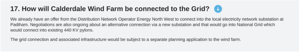
The embedded capacity register of Electricity North West in fact showed that CWF was not accepted to connect at Padiham, but at much more distant Rochdale. The FAQ also states that the National Grid runs at 440 Kelvin Volts. No reputable wind farm developer makes any of these mistakes. We were dealing with amateurs.
Readers of Windpower Monthly will search in vain for CWF Ltd’s reputation in the field, but if they want to try, the full name of founder and Executive Chairman is Christopher David Griffin Wilson, but they might start in Gibraltar with WWRE Global Ltd.
Wind farm professionals will already be shaking their heads in wonder at the incompetence of CWF Ltd and we are only one FAQ into the first proposal. We cannot give a full account of the collapse of CWF, but readers who follow the links will discover that every statement and map published by CWF Ltd must be checked by the competent public because they are always riddled with mistakes. Even the corrections are wrong. A fairly comprehensive list of CWF Ltd incompetence will be found here.
The initial CWF proposal was withdrawn a fortnight after the FAQ 17 errors (and many others) were pointed out, and the CWF Ltd website was jet-washed of all the damaging mistakes. The campaign has a full set of screenshots, of course. CWF Ltd’s own lead consultant Donald Mackay says of CWF, “It was worse than useless.” Engagement with the community had proved rather bruising for Executive Chairman Christopher Wilson and CWF Ltd.
What happened next?
The second proposal on Walshaw Moor is for a 41-turbine wind farm at 302 MW called Calderdale Energy Park (CEP). The public were informed of the “largest wind farm in England” a week before launch with a glossy leaflet in which the layout map was completely blank. The proposal was launched on 29 April at 9 a.m. There was a suite of seven maps showing the layout, peat depths, cultural heritage, access and so on. Every map was wrong in the most comical and revealing way.
All the maps of the 41-turbine layout showed a T42 and no T38. It was going to be a 42-turbine wind farm, but Project Director Christian Egal had a wobble right at the end of the design meeting (at 16.25 on Friday 21 February 2025) and deleted T38.
T38 had been in row 38 of the six-fig layout spreadsheet. When it was deleted, there was still a T42, now sitting in row 41. This Excel spreadsheet was sent to the map makers, who faithfully made a layout map from the spreadsheet, finishing it on 14 March 2025.
Project Director and new broom Christian Egal noticed the T42/T38 problem in early April, and new maps were made on 18 April, but nobody loaded them to the website for Launch Day eleven days later and nobody checked.
The blunder was pointed out to CWF Ltd by a member of the public at 9.04 a.m. On 1 May 2025, and a popup correction appeared on the website 86 minutes later. As always with CWF Ltd, the corrections always make their problem worse.
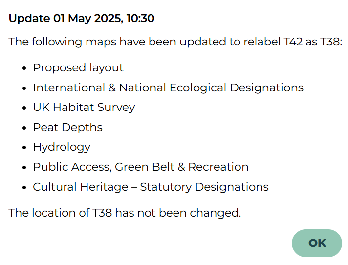
The statement that “The location of T38 has not been changed” is implausible on the internal evidence and CWF’s own lead consultant didn’t waste any time or personal reputation on the cover-up. “T38 was on the blank section of the peat survey, so we moved it.” Expert readers who look at the CEP layout numbering will see at once how unsustainable this cover-up was. They will again be shaking their heads in amazement both at the errors and the transparently false and pointless cover up.
This parade of incompetence on Launch Day was of a piece with the previous incompetence of CWF Ltd. Some idea of its full extent will be found here. All this incompetence has been put to CWF Ltd for comment, is in the public domain, and is the subject of legal letters now on file at the Planning Inspectorate.
A second error on the peat depth map scale was also pointed out on 1 May. This was corrected by hand insertion of a sticker into thousands of glossy brochures. “Like schoolboys completing their Italia 90 Panini Albums” said one observer.
Both errors were systemic. They were caused by the failure to complete the peat survey, which could have been done on almost any day between 1 August 2022 and 29 April 2025 for no more than £1000. When the investors have their post-mortem into CWF Ltd, this failure will be high on the list.
Many readers are reputable developers and consultants. In your life have you ever seen such incompetence?
As well as the publication to the British public of seven maps with a T42 on them, CWF Ltd held three events (Oxenhope, Hebden Bridge, Trawden) at places near the boundary of CEP. The behaviour of the consultants at two of these meetings has been widely published. Readers will recognise the consultant-types described. One of them, Donald Mackay, is outstanding, and a fish out of water amid such incompetence.
The whole “public consultation” (it ran for six weeks) was unlawful under the Gunning Principles, because it was not possible for a member of the public to give ‘intelligent consideration’ to the proposal, which is the legal test. This was principally because the proposal was obviously not a credible wind farm, a fact that will be immediately clear to every reader who looks at the layout map and remembers the rotor diameter is 162 metres. The public could not help but notice other weird errors.
What was wrong with the design process of CEP?
The primary parameters in a wind farm design are hub height and rotor diameter. A wake of slow moving, turbulent area forms behind a wind turbine and needs to fill with fast air before the next turbine down wind. The turbine spacing is usually 3 RD rows by 5 RD downwind to minimise wake loss in the array without having to buy too much land. If the wind comes powerfully from more than one direction a 5 RD by 5 RD layout might be used, as at Carrick (89 MW Galloway).
The next four maps show part of Whitelee, Scout Moor, part of Viking Shetland and the collapsed 65-turbine CWF each with the 3 RD by 5 RD footprint in the direction of a SW wind. The spreading lines represent the wake, and the circle is to scale with the swept area of the blades. The first map shows just 10% of the excellent Whitelee 529 MW, south of Glasgow off the M77
Next is Scout Moor WF just north of Rochdale.
Viking Shetland is badly overcrowded because of turbine uprating during the long gestation.
The overcrowding in Viking Shetland is caused by turbine power uprating without resiting during the proposal. It is unsatisfactory, but the national problems with Viking Shetland are more extensive than a slightly overcrowded layout and are an embarrassment to all who care about UK electricity generation, which in the end is every billpayer. The Prime Minister himself has promised to come down hard on these shenanigans which blight the reputation of wind power in the UK.
Finally here is the competent layout of the original Calderdale Wind Farm 65-turbine proposal. There is loads wrong with this “worse than useless” windfarm, but it started with correct spacing.
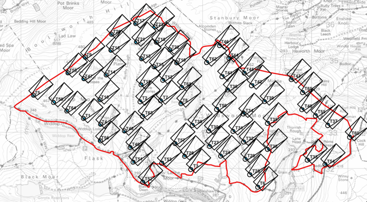
What does the layout of CEP look like?
Here is Calderdale Energy Park, put forward for public consultation.
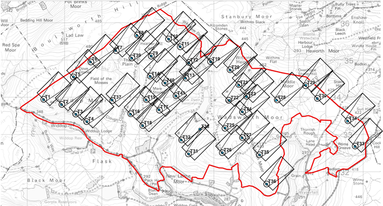
It is immediately apparent that CEP is not the result of a reputable design process that began with aerodynamics. It is grossly overcrowded.
What Project Director Christian Egal and his consultants actually did in the layout meeting on 21 February 2025 has been reconstructed from the maps, admissions made by the consultants at the so-called public exhibitions, admissions made in the CEP Webinar, the sequential numbering, and information passed to us by a mole we call “Deep Stoat”. An account of the design meeting based on this information will be published in August 2025. What the consultants did not do is start with a correct aerodynamic layout, but readers here do not need to be told that.
Since the public cannot give “intelligent consideration” to a proposal that is so far removed from a professionally designed wind farm, the public consultation was unlawful under the Gunning Principles. This point has been made to the CWF Ltd in an exchange of legal letters and the CWF Ltd lawyers have been unable to find arguments to contest the point. Until they do, no lawful public consultation on CEP has taken place.
Many readers will find the behaviour of CWF Ltd to be a menace to the reputation of all onshore wind in England.
What concessions, if any, would the campaign be willing to consider or listen to from CWF Ltd?
The British public has not been shown a professionally designed wind farm on Walshaw Moor. A necessary condition to anyone giving “intelligent consideration” to CWF Ltd’s proposals is that they should be competent in the first place. We await a lawful public consultation on a professionally designed wind farm, as, surely, does the Planning Inspectorate. We shall need ample time to check all the documents first, and we suggest a six-month buffer before the public consultation so the public can do the necessary field work, given the three-year history of incompetence.
One member of the campaign has twice offered the investors his help as an expert witness should they want to get some of their money back from Christopher ‘440 Kelvin Volts’ Wilson and CWF Ltd. Britain needs foreign investment, and it is not good for our international reputation to have such comical incompetence on such a famous site. The stepping back of Dr Ghazi Mohammed Osman as person with significant control over CWF Ltd on 19 May 2025 may be the first step in a distancing process that ends in the Chancery Division of the High Court. Nobody with Dr Osman’s stellar reputation wants to become a figure of fun.
With Dr Osman’s backwards step, Companies House are currently investigating the PSC register of CWF Ltd. Since the company is now interacting with government agencies (Natural England, Planning Inspectorate) the control chain of CWF Ltd should be transparent. CWF Ltd have admitted that the position in the Register represents the actual position.
If the CEP planning process continues, what could CWF Ltd do for the local community that would help improve the situation?
CEP is an NSIP. The report Unlocking benefits for people, nature and climate: Actions to jointly address climate change and biodiversity loss in England indicates government policy on these national and international matters. Actions for the local community cannot address the national and international problems of CEP.
The local issue that must be addressed is flooding, where CWF Ltd and the Planning Inspectorate would risk corporate manslaughter charges were the published proposal to go ahead. Walshaw Moor is known to be a dangerous catchment and there have been three severe or catastrophic floods in the Calder Valley since 2000. Because CEP is not professionally designed for aerodynamics, it is also not professionally designed for hydrology.
There is no point discussing hydrology until there is a credible layout to put to the public for intelligent consideration. We note however that the present hydrology map has an enormous error in its mapping of the Greave Clough catchment, caused by a failure to make effective site visits. CWF Ltd have spent £33,000 on ineffective site visits, and they still haven’t discovered the Greave Clough sluice and tunnel.
Why do the proposals for Calderdale Wind Energy Park pose such a danger to ecology?
Walshaw Moor has international ecology and habitat designations and as we shall see its doubly protected international status now has a world significance under the Kunming-Montreal Framework.
Walshaw Moor is a Special Area of Conservation for its irreplaceable peatland habitats, and a Special Protection Area for its assemblages of red-listed birds: merlins, golden plovers, curlews and lapwings. These charismatic birds are endangered almost everywhere but thrive on Walshaw Moor.
The SAC and SPA designations stem from European law (Walshaw Moor is a Natura 2000 site) carried over into British law despite a hard Brexit. The EU was not going to have anything to do with us if we were going to trash the environment. As the Scoping Report for CWF said “The proposal has the potential to cause negative, long-term, international, irreversible degradation and loss to habitats.”
Walshaw Moor is not a “local moor for local people.” Walshaw Moor has the highest wildlife and habitat designations of any land in the UK. Many professionals will be thinking, “SAC and SPA! What was this Christopher Wilson playing at?”
There is an even more important matter at stake; the Kunming-Montreal Global Biodiversity Framework.
Why does the Kunming-Montreal GBF effect Walshaw Moor?
A clear account is given in “Unlocking benefits…” (July 2025) which makes the government’s position clear on the K-M GBF which we signed (indeed we led) in 2024, as did 190 other nations. We would urge every consultant and wind farm developer to read this report as soon as possible.
The policy has a forward by the Ministers for Climate Change and Nature at DESNZ and Defra, respectively Kerry McCarthy and Mary Creagh.
“Climate change and biodiversity loss are among the greatest challenges of our time. They are deeply interconnected, and so too must be our response. The United Kingdom, alongside UK Overseas Territories and Crown Dependencies, is committed to delivering ambitious, coherent action that addresses these challenges – because it’s the right choice for today and for future generations. The UK remains steadfast in its commitment to the three ‘Rio’ Conventions that aim to protect the global environment, and to the landmark Paris Agreement and Kunming Montreal Global Biodiversity Framework (GBF).”
The K-M GBF has as its most famous target the 30 by 30 commitment. The report explains what this is.
“The 30 by 30 commitment sits at the very heart of the UK’s aim to ensure nature’s recovery. Delivering this target means ensuring that the most important and wildlife-rich habitats are benefiting from effective, long-term conservation and management. At CBD COP16 in October 2024, the UK confirmed its vision for delivering 30 by 30 in England and published the criteria for land and inland water areas which can count towards this target. At least 7.1% of England’s land has been identified that already meets the 30 by 30 criteria and counts towards the target. This includes Sites of Special Scientific Interest in favourable or unfavourable recovering condition, plus areas of the Public Forest Estate managed for biodiversity. While it is expected that there is additional land already meeting the criteria, such as NGO reserves, this illustrates the scale of action needed to achieve this target. An action plan for 30 by 30 on land is being developed, to ensure this commitment can be achieved. The aim is to finalise and publish this action plan later in 2025.”
The problem for England (conservation is devolved) is that it is one of the most nature-depleted countries on Earth. We talk big about other people’s nature: “Stop eating pangolins! Stop harpooning whales! Stop selling ivory!”) while we relentlessly destroy our own wildlife and habitats. The policy document claims global leadership in conservation but then admits that only 7.1% of England qualifies for our 30% by 2030. The global south already assumes England is hypocritical on nature.
The 7.1% that already meets the criteria is the internationally designated SPAs and SACs and includes Walshaw Moor. The remaining 23% will be patched together somehow. Defra state that land outside the designations will have to be legally safe from development for at least 20 years. The problem is made clear in the map below. The red is the 7.1% and of course includes doubly internationally designated Walshaw Moor. The blue needs a huge amount of work.
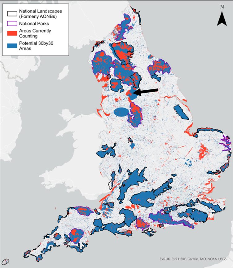
If Walshaw Moor, part of the 7.1 % that is meant to be anchoring the policy, can be completely destroyed by a wind farm, just three years after the submission of a comedy Scoping Report that CWF Ltd’s leading consultant says was “worse than useless,” then the whole 30 by 30 plan in England unravels. No land would be legally safe from destruction. We would then have 0% by 2030.
England does not have pangolins or elephants, and we do not harpoon whales, but we do have outstanding charismatic birds breeding on the irreplaceable peatland habitats of Walshaw Moor, and they do better there than anywhere else in England or Scotland.
The seriousness cannot be overstated. The Kunming-Montreal GBF international policy, a triumph of British diplomacy, could unravel on Walshaw Moor in 2026. The global south would say, “The English hypocrites couldn’t even keep their hands off their pathetic 7.1%.”
Do you agree that the UK needs more wind energy capacity to meet its climate commitments?
Nobody knows better than readers of Windpower Monthly that the NESO TEC register already has ten times more wind energy queued up than is required by 2040. The problem is not that we don’t have enough wind generation, but that we don’t know where to build the transmission because the wind farm proposals are all over the shop in a gold rush.
Onshore wind in England is determined by the whims of rich landowners. Onshore wind in England should be NESO-led, not landowner-led. Part of the problem is that the TEC register has failed and speculative projects cluttering it up. Two of these are collapsed Calderdale Wind Farm proposals which should have been removed in October 2024 and are shown below in the latest update. The reference to “CWF 275 kV substation” is to a non-existent facility that might as well be in Narnia. Here is 482 MW clogging up the TEC register for more reputable projects that readers may be trying to get connected.
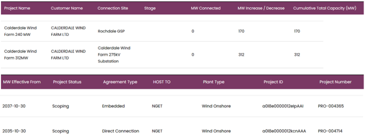
[Two CWF Ltd projects clogging up the NESO TEC register with 482 MW of collapsed wind farm. NESO TEC register screenshot: Nick MacKinnon]
Where should the turbines be built?
There is a remarkable map, published by Friends of the Earth, who are even more enthusiastic for onshore wind than Windpower Monthly, which shows the vast available area for wind turbines within 5 km of a substation. The Friends map avoids the internationally designated land (Dartmoor, single-designated Exmoor, the Farne Islands and double-designated Walshaw Moor, for example) and the less protected (because only nationally designated) National Parks like the Lake District and the New Forest. The Friends map puts a 2 km buffer around the internationally and nationally designated land and finds that we can have fifty times more wind and solar in the UK than we presently have. There is therefore absolutely no need to tear up our international treaties or build wind farms in the Norfolk Broads. These facts are well-known to all wind farm professionals.
Do you have a response to those who argue that the climate crisis and global heating poses the greatest single threat to ecology in moorland, bogs and peatland like this through e.g. increasing prevalence of wildfires, biodiversity collapse (and that to minimise those things, renewable energy is necessary)?
Wind farms drain peat and make it more likely to burn. The cheapest thing the UK can do to avert the next climate change tipping point is to rewet our blanket bogs, not dry them out. The tragedy of wind farms (and before that Sitka) on deep Scottish peat must not be repeated in England. The Scottish peat tragedy is what happens if you let the landowners decide where the wind farms are going. We should never again build a wind farm on deep peat.
Do practices like overgrazing and burning pose threats to this landscape and ecology?
Burning old heather will soon be forbidden on all deep peat. There is an agreement on Walshaw Moor between the Estate and Natural England, which we pay for, and which runs from 2018 to 2042. The Estate maintain the agreement rigorously. One consequence has been the extraordinary increase in red-listed birds breeding successfully on Walshaw Moor. It is a national wonderland.
Readers wishing to assess this point should walk a June morning on Walshaw Moor (so much curlew, lapwing and golden plover racket that you can’t hear the skylarks and meadow pipits) and another on high ground in the Yorkshire Dales National Park, which is almost silent. We need to find out why this is. We are delighted that Windpower Monthly is taking such an interest in the extraordinary ecology on Walshaw Moor.
The current definition of deep peat in England is 40 cm, but 30 cm will soon be the definition. Calderdale Energy Park will destroy vast areas of deep peat by direct excavation and subsequent drying. The drying effect is much more destructive, as expert readers know. The next tipping point in climate change is when uncontrolled wildfires occur in boreal forests and peat deposits in a ring around the Arctic at our latitude. The UK can have an extraordinarily strong leadership role on this point, because we have a lot of blanket bog. Scotland has begun to wake up to what they have done with their peat. England is already wide awake as government statements on peatland have demonstrated. Thanks to the Scottish tragedy, England will not make the same mistakes.
What about Kate Bush?
Walshaw Moor is one of the most famous pieces of high ground in the world and the inspiration of the Brontë Sisters, themselves three of the most famous women in world history. Nobody over 55 will forget the explosion of Kate Bush onto Top of the Pops on 16 February 1978. We had no idea this was coming! Hundreds of millions of people know now.
No government wants us to be a joke abroad. The fame of Walshaw Moor draws people from all over the world who will be astonished to find the UK plans a wind farm above Kate Bush’s Wuthering Heights. They will be even more astonished if the Kunming-Montreal treaty unravels on Walshaw Moor, as will Sir David Attenborough.
Since the cutting down of the tree in Sycamore Gap, for which the vandals will serve up to four years and three months at His Majesty’s Pleasure, the most iconic sycamores remaining in Britain are the two at Wuthering Heights.
Photo: Kate Haslegrave
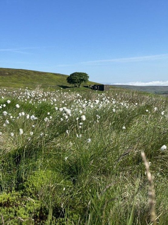
Thank you for helping readers to understand what is happening on Walshaw Moor
It is a pleasure to introduce expert readers, naturally up-to-speed on the technicalities, to the bog that CWF Ltd have got themselves into. This company had no reputation when it was started, and its present reputation, laid out in these answers to your questions, brings all of UK onshore wind into disrepute. If responsible professionals speak out against CWF Ltd, it will be a positive contribution to the health and future of a vital industry.
Privacy policy
This privacy notice for Walshaw Turbines Research Group describes how we might use your personal information. It was last updated on 27 May 2025
What personal information do we process.?
We do not process any of your information.
Do we collect any of your information?
We do not collect your information.
Do we collect information from third parties?
We do not collect information from third parties.
Questions or concerns If you still have questions or concerns please contact us at nipmackinnon@gmail.com